IMAGES TAKEN NEAR TO
Longfield Road, STOKE-ON-TRENT, ST4 6QW
Introduction
This page details the photographs taken nearby to Longfield Road, ST4 6QW by members of the Geograph project.
The Geograph project started in 2005 with the aim of publishing, organising and preserving representative images for every square kilometre of Great Britain, Ireland and the Isle of Man.

There are currently over 7.5m images from over14,400 individuals and you can help contribute to the project by visiting https://www.geograph.org.uk
Image Map
Images are licensed for reuse under creativecommons.org/licenses/by-sa/2.0
Notes
- Clicking on the map will re-center to the selected point.
- The higher the marker number, the further away the image location is from the centre of the postcode.
Image Listing (94 Images Found)
Images are licensed for reuse under creativecommons.org/licenses/by-sa/2.0
Image
Details
Distance
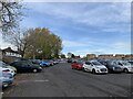
1
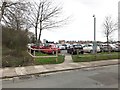
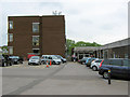
Hartshill: hospital car park
This large car park occupies the site of the former North Staffs Hospital's Central Outpatients Department and Pathology laboratories. The wall and steps can be seen on the extreme left of http://www.geograph.org.uk/photo/4152637 when demolition was underway in August 2013. The sign on the wall directs the reader up the steps to the now vanished 'Central Outpatients Department Main Entrance'.
Image: © Jonathan Hutchins
Taken: 14 Mar 2017
0.06 miles
3
Hartshill: hospital car park
This enlarged car park occupies the site of the former North Staffs Hospital's Central Outpatients Department and the Pathology laboratories.
Image: © Jonathan Hutchins
Taken: 14 Mar 2017
0.07 miles
4
Royal Stoke University Hospital staff car park
On the site of the former Central Outpatients and Pathology departments and their car parks. These departments' services have been reprovided within the main hospital building a short distance away.
Image: © Jonathan Hutchins
Taken: 14 Nov 2018
0.08 miles
5
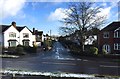
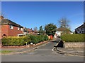
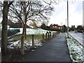
Hartshill: Longfield Road from Albany Road
Image: © Jonathan Hutchins
Taken: 30 Jan 2015
0.08 miles
6
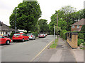
Unnamed street
This unnamed street runs from the car park at the back of the Image down to The Avenue.
Image: © Jonathan Kington
Taken: 26 May 2010
0.09 miles
7
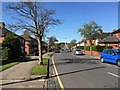
Hartshill: junction of Albany Road and The Avenue
Image: © Jonathan Hutchins
Taken: 29 Jan 2015
0.10 miles
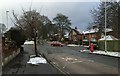
8
Hartshill: Albany Road
At this point Hilton Road, a dual carriageway running NNW, suddenly bears to the right and becomes a two-lane highway called Albany Road. OS maps suggest that at some time Hilton Road continued straight on up the grassy slope to the left, which now leads up to a short cul-de-sac.
Image: © Jonathan Hutchins
Taken: 29 Jan 2015
0.10 miles
9
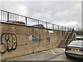
Central Outpatients Department
The entrance to the Central Outpatients Department of the University Hospital of North Staffordshire (UHNS). The large brick building on the left houses the Pathology laboratories.
Update June 2018: The buildings have now been demolished (see Image ) and the laboratories have moved to a new site in Newcastle-Under-Lyme. Many thanks to Chris Allen for keeping me informed.
Image: © Jonathan Kington
Taken: 26 May 2010
0.11 miles