IMAGES TAKEN NEAR TO
Diarmid Road, STOKE-ON-TRENT, ST4 4QS
Introduction
This page details the photographs taken nearby to Diarmid Road, ST4 4QS by members of the Geograph project.
The Geograph project started in 2005 with the aim of publishing, organising and preserving representative images for every square kilometre of Great Britain, Ireland and the Isle of Man.

There are currently over 7.5m images from over14,400 individuals and you can help contribute to the project by visiting https://www.geograph.org.uk
Image Map
Images are licensed for reuse under creativecommons.org/licenses/by-sa/2.0
Notes
- Clicking on the map will re-center to the selected point.
- The higher the marker number, the further away the image location is from the centre of the postcode.
Image Listing (47 Images Found)
Images are licensed for reuse under creativecommons.org/licenses/by-sa/2.0
Image
Details
Distance
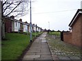
1

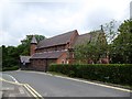
Hanford: track between houses off Diarmid Road
Image: © Jonathan Hutchins
Taken: 18 Jun 2016
0.03 miles

4
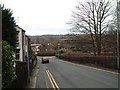
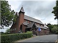
Church Lane, Hanford
Looking down Church Lane. In the centre, right is the M6 junction 15 flyover.
See picture of St. Matthias Church:- http://www.geograph.org.uk/photo/345789
Image: © Steven Birks
Taken: 23 Feb 2007
0.09 miles
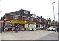
10
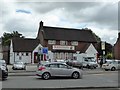
Hanford: Krishna's restaurant
This was formerly a pub called 'The Staffordshire Knot.'
Image: © Jonathan Hutchins
Taken: 18 Jun 2016
0.13 miles