IMAGES TAKEN NEAR TO
Whieldon Industrial Estate, Whieldon Road, STOKE-ON-TRENT, ST4 4JP
Introduction
This page details the photographs taken nearby to Whieldon Industrial Estate, Whieldon Road, ST4 4JP by members of the Geograph project.
The Geograph project started in 2005 with the aim of publishing, organising and preserving representative images for every square kilometre of Great Britain, Ireland and the Isle of Man.

There are currently over 7.5m images from over14,400 individuals and you can help contribute to the project by visiting https://www.geograph.org.uk
Image Map
Images are licensed for reuse under creativecommons.org/licenses/by-sa/2.0
Notes
- Clicking on the map will re-center to the selected point.
- The higher the marker number, the further away the image location is from the centre of the postcode.
Image Listing (67 Images Found)
Images are licensed for reuse under creativecommons.org/licenses/by-sa/2.0
Image
Details
Distance


3
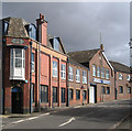
Fenton - Keeling & Walker works
On Whieldon Road.
Image: © Dave Bevis
Taken: 3 Oct 2012
0.07 miles
4

Fenton, Stoke-on-Trent: Keeling and Walker factory, Whieldon Road
Seen from a passing train. Keeling and Walker, according to the sign on the side of the factory, deal in Thermox performance materials.
Image: © Christopher Hilton
Taken: 25 Jul 2013
0.08 miles
5
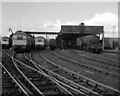
Stoke locomotive depot
A selection of steam and diesel locomotives at Stoke depot, shortly before closure. BR Type 2 diesel electric (class 24 or 25) and Stanier Black 5 locos are visible.
This part of the depot (Pratt Sidings, north of the old line to Biddulph and Leek) is now an industrial estate.
There was also a roundhouse on the west side of the main line to the south (Stone).
Image: © Ian Taylor
Taken: 15 Oct 1967
0.15 miles
6
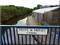
Whieldon Road crossing the Trent & Mersey Canal
Image: © Mat Fascione
Taken: 11 Jul 2015
0.15 miles
7
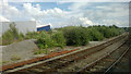
Stoke junction: line to Derby diverges from the main line south
To the left, big retail sheds occupying formerly industrial land.
Image: © Christopher Hilton
Taken: 25 Jul 2013
0.15 miles
8
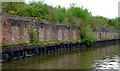
Disused wharf near Mount Pleasant, Stoke-on-Trent
South of Whieldon Road Bridge (No 110*) on the Trent and Mersey Canal. This canal frontage is long, with evidence that narrowboat loading could be done at many places. It was the Colonial Pottery of Winkle and Company, and opened here in 1889. Just beyond it to the south was a brick works which has also been demolished. http://www.thepotteries.org/photos/wieldon_road/index.htm
* Nicholson Guides have this as Bridge No 112.
Image: © Roger D Kidd
Taken: 30 May 2011
0.15 miles
9
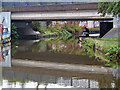
Whieldon Road Bridge in Stoke-on-Trent
This is the Trent and Mersey Canal in Stoke-on-Trent, looking south-east under Whieldon Road Bridge, No 110. Nicholson Guides have this as Bridge No 112.
Image: © Roger Kidd
Taken: 16 Sep 2019
0.15 miles