IMAGES TAKEN NEAR TO
Mabel Smith Walk, STOKE-ON-TRENT, ST4 4FT
Introduction
This page details the photographs taken nearby to Mabel Smith Walk, ST4 4FT by members of the Geograph project.
The Geograph project started in 2005 with the aim of publishing, organising and preserving representative images for every square kilometre of Great Britain, Ireland and the Isle of Man.

There are currently over 7.5m images from over14,400 individuals and you can help contribute to the project by visiting https://www.geograph.org.uk
Image Map
Images are licensed for reuse under creativecommons.org/licenses/by-sa/2.0
Notes
- Clicking on the map will re-center to the selected point.
- The higher the marker number, the further away the image location is from the centre of the postcode.
Image Listing (75 Images Found)
Images are licensed for reuse under creativecommons.org/licenses/by-sa/2.0
Image
Details
Distance
1
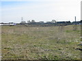
The Old Victoria Ground
This shows the site of the old Victoria Ground the home of Stoke City for over 100 years now awaiting development (Mar 06). On the horizon, centre picture can be seen one of the stands at the Britannia Stadium the clubs present ground.
Image: © Phil Eptlett
Taken: 22 Mar 2006
0.07 miles

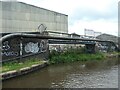
3
Former wharf site near Stoke-on-Trent
This is by the Trent and Mersey Canal near Mount Pleasant. Modern industrial warehouses and manufacturing units now occupy the site bsouth of Whieldon Road. I think it used to be occupied by a brickworks. Behind the camera used to be the Colonial Pottery.
Image: © Roger Kidd
Taken: 10 Sep 2014
0.11 miles
4
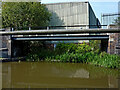
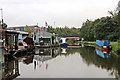
Canal boatyard in Stoke-on-Trent
This is the Trent and Mersey Canal in Stoke-on-Trent, looking south-east towards Whieldon Road Bridge, No 110.
Image: © Roger Kidd
Taken: 16 Sep 2019
0.11 miles
5
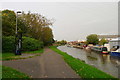
The Trent and Mersey Canal near Whieldon Road
Fishing is restricted by the overhead power lines
Image: © Tim Heaton
Taken: 16 Oct 2017
0.11 miles
6
Canal and boatyard in Stoke-on-Trent
This is the Trent and Mersey Canal in Stoke-on-Trent, looking south-east towards Whieldon Road Bridge, No 110.
Image: © Roger Kidd
Taken: 16 Sep 2019
0.12 miles
7
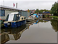
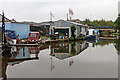
Moored boats in Stoke-on-Trent
This is by a boatyard on the Trent and Mersey Canal in Stoke-on-Trent, looking south-east towards Whieldon Road Bridge, No 110.
Image: © Roger Kidd
Taken: 16 Sep 2019
0.12 miles
8
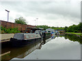
Trent and Mersey Canal near Mount Pleasant, Stoke-on-Trent
The boatyard on the left is north of Whieldon Road Bridge, No 110. Nicholson Guides have this as Bridge No 112.
The canal is 93.5 miles in length from Derwent Mouth to Preston Brook. The first sod was cut by Josiah Wedgwood in July 1766 at Middleport (Stoke-on-Trent). It took eleven years to build. James Brindley was the engineer until his death in 1772.
Image: © Roger D Kidd
Taken: 30 May 2011
0.12 miles
9
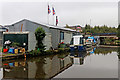
Boatyard workshop in Stoke-on-Trent
This is by the Trent and Mersey Canal in Stoke-on-Trent, looking south-east towards Whieldon Road Bridge, No 110.
Image: © Roger Kidd
Taken: 16 Sep 2019
0.12 miles
10
Disused canal arm, now built over
Once a busy wharf on the opposite bank to the Colonial Pottery [which made earthenware]. Now home to D Tec Fabrications Ltd. The bridge carries the canal towpath
Image: © Christine Johnstone
Taken: 25 Sep 2020
0.12 miles