IMAGES TAKEN NEAR TO
Caledonia Road, STOKE-ON-TRENT, ST4 2DN
Introduction
This page details the photographs taken nearby to Caledonia Road, ST4 2DN by members of the Geograph project.
The Geograph project started in 2005 with the aim of publishing, organising and preserving representative images for every square kilometre of Great Britain, Ireland and the Isle of Man.

There are currently over 7.5m images from over14,400 individuals and you can help contribute to the project by visiting https://www.geograph.org.uk
Image Map
Images are licensed for reuse under creativecommons.org/licenses/by-sa/2.0
Notes
- Clicking on the map will re-center to the selected point.
- The higher the marker number, the further away the image location is from the centre of the postcode.
Image Listing (172 Images Found)
Images are licensed for reuse under creativecommons.org/licenses/by-sa/2.0
Image
Details
Distance
1
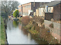
Caldon Canal, Hanley
This is looking towards the junction with the Trent & Mersey Canal main line from the Stoke Road bridge. The Caldon Canal was originally opened in 1779 as an outlet for limestone quarried in the Froghall area. Like many canals it suffered a slow decline and might easily have disappeared altogether had it not been for the efforts of local volunteers which led to a full restoration for navigation in 1974.
Image: © Stephen McKay
Taken: 26 Jan 2010
0.03 miles

3
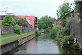
Caldon Canal near Shelton, Stoke-on-Trent
This is the canal west of Planet Lock. Many of the old factory buildings and workshops are being demolished in this area of Stoke, regeneration of the land being very extensive.
Image]
The Caldon Branch of the Trent and Mersey Canal opened in 1779. It runs eighteen miles from Etruria in Stoke-on-Trent, where it leaves the Trent and Mersey Canal. It terminates at Froghall about five miles south-east of Cheddleton. The canal has seventeen locks and the 69 metre long very low Froghall Tunnel, unusable by many narrowboats. The canal did originally continue through to Uttoxeter, but the section beyond Froghall was closed by the mid 1840s, much of its course being filled in to construct a railway.
Image: © Roger D Kidd
Taken: 27 May 2011
0.03 miles
4
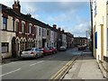
Pyenest Street
Pyenest Street, Snow Hill, Hanley
Runs parallel to the Caldon Canal
Image: © Steven Birks
Taken: Unknown
0.04 miles
5
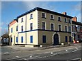
Pottery Works, Snow Hill, Stoke-on-Trent
Old pottery works on the corner of Howard Place and Pyenest Street (Snow Hill), Stoke-on-Trent.
Image: © Steven Birks
Taken: 23 Nov 2006
0.04 miles
6
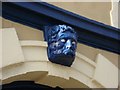
Face over entrance arch to pottery works
Appears over the entrance to the pottery works on the corner of Pyenest Street and Howard Place, Snow Hill, Stoke-on-Trent
Image: © Steven Birks
Taken: 23 Nov 2006
0.04 miles
7
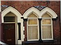
Window detail in Pyenest Street, Snow Hill, Hanley
The Houses in the street have amazing architectural features adorning the frontage.
These Gothic style windows are adorned with an arch of bricks with a mosaic of Minton tiles.
See a view of the street:- http://www.geograph.org.uk/photo/332776
Image: © Steven Birks
Taken: Unknown
0.04 miles
8
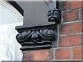
"Faces at the Window", Pyenest Street, Snow Hill
At the base of the Gothic arch is a green man and on at the corner a little gargoyle face. All of the houses on this side of the street have different emblemishes around the windows.
See a photo of the Gothic windows:- http://www.geograph.org.uk/photo/345896
See a photo of the street:- http://www.geograph.org.uk/photo/332776
Image: © Steven Birks
Taken: Unknown
0.04 miles
9
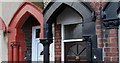
Faces and Flowers at every corner, Pyenest Street, Snow Hill
Every corner of the window and door pillars and columns have a face, flower or leaves and each house is different.
See the main street: http://www.geograph.org.uk/photo/332776
Image: © Steven Birks
Taken: Unknown
0.04 miles
10
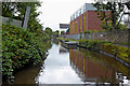
Caldon Canal west of Hanley Park, Stoke-on-Trent
This shows the Caldon Canal south-east of Shelton New Road Bridge, No 3. The modern building on the right is part of Stoke-on-Trent College.
Image: © Roger Kidd
Taken: 12 Sep 2019
0.04 miles