IMAGES TAKEN NEAR TO
Buskins Grove, STOKE-ON-TRENT, ST3 6QP
Introduction
This page details the photographs taken nearby to Buskins Grove, ST3 6QP by members of the Geograph project.
The Geograph project started in 2005 with the aim of publishing, organising and preserving representative images for every square kilometre of Great Britain, Ireland and the Isle of Man.

There are currently over 7.5m images from over14,400 individuals and you can help contribute to the project by visiting https://www.geograph.org.uk
Image Map (Loading...)


Getting Data...Please wait
Leaflet Map data © OpenStreetMap
Images are licensed for reuse under creativecommons.org/licenses/by-sa/2.0
Notes
- Clicking on the map will re-center to the selected point.
- The higher the marker number, the further away the image location is from the centre of the postcode.
Image Listing (6 Images Found)
Images are licensed for reuse under creativecommons.org/licenses/by-sa/2.0
Image
Details
Distance
1
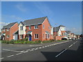
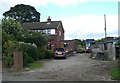
Main Street, Weston Coyney
The junction of Main Street, on the right, with Flint Street.
Image: © David Weston
Taken: 10 Aug 2017
0.05 miles
2
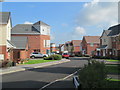
Gate Street, Weston Coyney
Viewed from the junction with Flint Street.
Image: © David Weston
Taken: 10 Aug 2017
0.06 miles
3
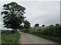
Roughcote Lane
On the right is New Roughcote Farm.
Image: © David Weston
Taken: 17 Jun 2014
0.20 miles
4
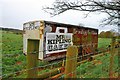
Horsebox on Roughcote Lane
This box has been removed from a truck and converted into a horsebox as the opposite end has the typical door/flap, and along the top edge are vents for allowing the horses to breathe during hot weather. The wheels are missing.
Image: © Stu JP
Taken: 30 Mar 2015
0.21 miles
6
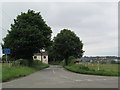
Crossroads at Roughcote
Looking south along Roughcote Lane.
Image: © David Weston
Taken: 17 Jun 2014
0.25 miles