IMAGES TAKEN NEAR TO
Weldon Avenue, STOKE-ON-TRENT, ST3 6PN
Introduction
This page details the photographs taken nearby to Weldon Avenue, ST3 6PN by members of the Geograph project.
The Geograph project started in 2005 with the aim of publishing, organising and preserving representative images for every square kilometre of Great Britain, Ireland and the Isle of Man.

There are currently over 7.5m images from over14,400 individuals and you can help contribute to the project by visiting https://www.geograph.org.uk
Image Map (Loading...)


Getting Data...Please wait
Leaflet Map data © OpenStreetMap
Images are licensed for reuse under creativecommons.org/licenses/by-sa/2.0
Notes
- Clicking on the map will re-center to the selected point.
- The higher the marker number, the further away the image location is from the centre of the postcode.
Image Listing (8 Images Found)
Images are licensed for reuse under creativecommons.org/licenses/by-sa/2.0
Image
Details
Distance
1
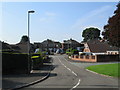
Weldon Avenue, Weston Coyney
Looking towards the junction with Caverswall Road.
Image: © David Weston
Taken: 10 Aug 2017
0.06 miles
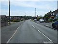
6
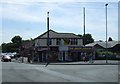
Main Street, Weston Coyney
The junction of Main Street, on the right, with Flint Street.
Image: © David Weston
Taken: 10 Aug 2017
0.21 miles
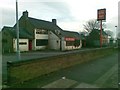
7
Gate Street, Weston Coyney
Viewed from the junction with Flint Street.
Image: © David Weston
Taken: 10 Aug 2017
0.23 miles
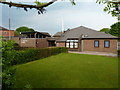
8
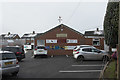
The Club house
Caverswall Cricket Club club house. I was told it is open at some time all 365 days in the year as a social centre for the area but is of course especially busy on weekends in the summer when it hosts several matches each weekend.
Image: © Malcolm Neal
Taken: 31 Jan 2019
0.25 miles