IMAGES TAKEN NEAR TO
Beckenham Close, STOKE-ON-TRENT, ST3 6HW
Introduction
This page details the photographs taken nearby to Beckenham Close, ST3 6HW by members of the Geograph project.
The Geograph project started in 2005 with the aim of publishing, organising and preserving representative images for every square kilometre of Great Britain, Ireland and the Isle of Man.

There are currently over 7.5m images from over14,400 individuals and you can help contribute to the project by visiting https://www.geograph.org.uk
Image Map
Images are licensed for reuse under creativecommons.org/licenses/by-sa/2.0
Notes
- Clicking on the map will re-center to the selected point.
- The higher the marker number, the further away the image location is from the centre of the postcode.
Image Listing (15 Images Found)
Images are licensed for reuse under creativecommons.org/licenses/by-sa/2.0
Image
Details
Distance
1
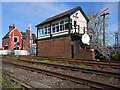
Caverswall Signal Box
Caverswall signal box is situated on the Derby - Stoke line of the former North Staffordshire Railway, it opened in 1942 to control new up and down goods loops provided as part of the war effort.
The box is a LMS 11c with wartime 14" thick brickwork for the base. The goods loops remain, although they see very little use these days. Lifting barriers replaced the level crossing gates here in 1983. Currently the box works Absolute Block to Foley Crossing and Uttoxeter.
Over the years the box has amassed further equipment, Blythe Bridge CCTV (08/03/1980), Stallington CCTV (12/03/1989), Cresswell AHB (18/03/1989), Upper Leigh and Leigh AHB's and provision of Up Main IBH at Lower Nobut (11/07/1999).
Image: © Nick Allsop
Taken: 10 Apr 2011
0.08 miles
2
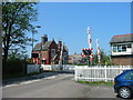
Caverswall Lane Crossing
Modern crossing gates on the Stoke - Derby railway line. The distinctive architecture of the old North Staffordshire Railway can be seen in the crossing keepers house beyond.
Image: © Phil Eptlett
Taken: 10 May 2006
0.09 miles
4
Westbound A50 access slip road, Meir Park
Image: © Richard Vince
Taken: 29 Jun 2013
0.16 miles
6
A50 - Uttoxeter Road junction bridges
The junction marks the entry into Stoke-on-Trent and reduction of the permitted speed limit to 50mph, essential in view of the series of closely-spaced junctions between this point and the A500.
Image: © Peter Whatley
Taken: 24 Mar 2011
0.21 miles
7
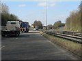
A50 approaching Uttoxeter Road junction (A521)
A classic UK roundabout junction with the added bonus of a Tesco superstore selling cheap fuel adjoining it.
Image: © Peter Whatley
Taken: 24 Mar 2011
0.21 miles
8
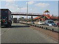
A50 - domed footbridge at Edenhurst Avenue
In dualling the A50 between Blythe Bridge and the A500, the builders employed a series of interesting footbridge designs. This is the first, with domes over the abutments.
Image: © Peter Whatley
Taken: 24 Mar 2011
0.23 miles