IMAGES TAKEN NEAR TO
Weston Coyney Road, STOKE-ON-TRENT, ST3 5HU
Introduction
This page details the photographs taken nearby to Weston Coyney Road, ST3 5HU by members of the Geograph project.
The Geograph project started in 2005 with the aim of publishing, organising and preserving representative images for every square kilometre of Great Britain, Ireland and the Isle of Man.

There are currently over 7.5m images from over14,400 individuals and you can help contribute to the project by visiting https://www.geograph.org.uk
Image Map
Images are licensed for reuse under creativecommons.org/licenses/by-sa/2.0
Notes
- Clicking on the map will re-center to the selected point.
- The higher the marker number, the further away the image location is from the centre of the postcode.
Image Listing (16 Images Found)
Images are licensed for reuse under creativecommons.org/licenses/by-sa/2.0
Image
Details
Distance
1
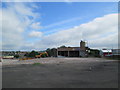
Site of demolished building, Longton
Seen from Uttoxeter Road, near the junction with Meir Hay Road.
Image: © David Weston
Taken: 17 Jun 2014
0.11 miles
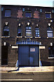
2
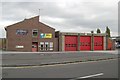
Longton fire station
Longton fire station, Uttoxeter Road, Longton, Staffordshire
Image: © Kevin Hale
Taken: 31 Oct 2007
0.15 miles
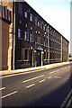
3
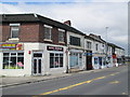
Shops on Uttoxeter Road, Longton
A row of shops on the edge of the town.
Image: © David Weston
Taken: 17 Jun 2014
0.17 miles
4
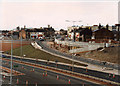
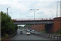
Old A50 and New A50 (under construction)
Taken during the summer of 1997 this show the Normacot junction of the almost finished A50 trunk road. In the centre is the old A50 towards Longton with the Shires bathroom factory towering over the terraced shops. It is currently empty awaiting demolition or refurbishment. Almost totally hidden behind the shops but this side of the bathroom factory is Longton Fire station. Further in the distance is St James' Church tower located on the south side of Uttoxeter Road.
Image: © Chris Beaver
Taken: Unknown
0.20 miles
5
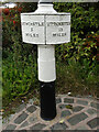
Old Milepost Uttoxeter Road
Cast iron post by the A5007 (was A50), in parish of STOKE ON TRENT (STOKE ON TRENT District), West of Longton town centre, King Street, in tarmac in front of brick wall, on Southwest side of road. Cobridge iron casting, erected by the Newcastle to Blythe Marsh turnpike trust in the 19th century.
Inscription reads:-
: NEWCASTLE / 5 / MILES // UTTOXETER / 13 / MILES
Maker:- : S.N. Cobridge :
Milestone Society National ID: ST_NCUT05
Image: © Ivan Clare
Taken: 4 Oct 2021
0.20 miles
6
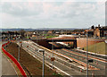
Normacot junction of A50 (under construction)
This shows the Normacot junction of the new and almost finished A50 taken during the summer of 1997. In the centre of the photo is the four-storey Sutherland Institute which houses Longton Library on the ground floor.
Image: © Chris Beaver
Taken: Unknown
0.21 miles
8
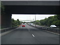
Normacot junction underpass
The A50 passes under the Uttoxeter Road; the walls of the underpass are lined with brick
Image: © David Smith
Taken: 23 Jul 2013
0.22 miles
9
Florence Works, Longton
Dated 1876 cast on beam above entrance. Described as a functional building with little display. Grid reference is from Fred Brook's book on the Industrial Archaeology of the West Midlands (1977). I haven't been back to this location since I took the photograph.
Closed and demolished in the 1990s - shame!
Image: © Chris Allen
Taken: Unknown
0.22 miles
10
Florence Works, Longton
This one appears not to have benefited from the Geograph treatment.
Closed and demolished in the 1990s and now a car park.
Image: © Chris Allen
Taken: Unknown
0.22 miles