IMAGES TAKEN NEAR TO
Sutherland Road, STOKE-ON-TRENT, ST3 1JB
Introduction
This page details the photographs taken nearby to Sutherland Road, ST3 1JB by members of the Geograph project.
The Geograph project started in 2005 with the aim of publishing, organising and preserving representative images for every square kilometre of Great Britain, Ireland and the Isle of Man.

There are currently over 7.5m images from over14,400 individuals and you can help contribute to the project by visiting https://www.geograph.org.uk
Image Map
Images are licensed for reuse under creativecommons.org/licenses/by-sa/2.0
Notes
- Clicking on the map will re-center to the selected point.
- The higher the marker number, the further away the image location is from the centre of the postcode.
Image Listing (60 Images Found)
Images are licensed for reuse under creativecommons.org/licenses/by-sa/2.0
Image
Details
Distance
1
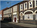
Florence Works, Longton
Dated 1876 cast on beam above entrance. Described as a functional building with little display. Grid reference is from Fred Brook's book on the Industrial Archaeology of the West Midlands (1977). I haven't been back to this location since I took the photograph.
Closed and demolished in the 1990s - shame!
Image: © Chris Allen
Taken: Unknown
0.09 miles
2
Florence Works, Longton
This one appears not to have benefited from the Geograph treatment.
Closed and demolished in the 1990s and now a car park.
Image: © Chris Allen
Taken: Unknown
0.09 miles
3

Site of demolished building, Longton
Seen from Uttoxeter Road, near the junction with Meir Hay Road.
Image: © David Weston
Taken: 17 Jun 2014
0.13 miles
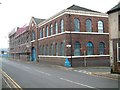
4
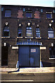
Adderley Works, Sutherland Road
A factory of the post war years. Even here, the original owners have continued the tradition of a relatively impressive entrance.
Image: © Alan Murray-Rust
Taken: 9 Sep 2007
0.13 miles
5
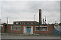
Tams Group - Blyth Works
Tams Group earthenware factory. Known as Blyh Works.
Uttoxeter Road, Normacot, Longton, Stoke-on-Trent
Image: © Steven Birks
Taken: Unknown
0.14 miles
6
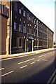
St. Mary's Works, Normacot
On Uttoxeter Road, Normacot, Longton
Buildings forming part of Pottery works. 1862. Brick with terracotta dressings and plain tiled roofs. 2-storeyed, 13 bays (6-1-6). Central pediment over entrance arch with Palladian window over, and cartouche in the apex, inscribed "St Mary's Mount Pleasant, 1862". This entrance bay is flanked by round arched windows recessed in brick architraves with rubbed brick arched heads and keyblocks. Continuous stuccoed sill bands, and stuccoed eaves cornice. Adjoining to the left, a further range added in 1888. 3 storeys, 8 bays (1-6-1) with outer gabled bays with inserted lower windows and tripartite window over, with terracotta panels beneath them, and stone string course.
Image: © Steven Birks
Taken: 5 Jan 2006
0.14 miles
7
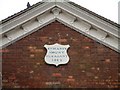
Date plaque on St. Mary's Works, Normacot
Central pediment over entrance arch with Palladian window over, and cartouche in the apex, inscribed "St Mary's Mount Pleasant, 1862".
See the works:- http://www.geograph.org.uk/photo/345121
Image: © Steven Birks
Taken: 5 Jan 2006
0.14 miles
8

Minkstone Works
Grade-II-listed, late 19th century brick bottle kiln at the former Minkstone Works, on the corner of Warren Street and Normacot Road.
Image: © Ashley Dace
Taken: 2 Mar 2012
0.15 miles
9
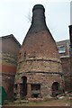
Disused Bottle Kiln
An early photograph Image] shows the kiln is deteriorating condition. The kiln is in a former works complex used by small businesses.
Image: © Ashley Dace
Taken: 2 Mar 2012
0.15 miles
10
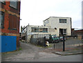
Former potteries, Warren Street, Longton
Dilapidated former pottery factories on Warren Street, just off Uttoxeter Road (A50). The tower in the distance is the church of St James and St John. The red-brick building on the left is also shown in Image
Image: © Espresso Addict
Taken: 13 Jan 2007
0.16 miles