IMAGES TAKEN NEAR TO
Drayton Road, STOKE-ON-TRENT, ST3 1BA
Introduction
This page details the photographs taken nearby to Drayton Road, ST3 1BA by members of the Geograph project.
The Geograph project started in 2005 with the aim of publishing, organising and preserving representative images for every square kilometre of Great Britain, Ireland and the Isle of Man.

There are currently over 7.5m images from over14,400 individuals and you can help contribute to the project by visiting https://www.geograph.org.uk
Image Map
Images are licensed for reuse under creativecommons.org/licenses/by-sa/2.0
Notes
- Clicking on the map will re-center to the selected point.
- The higher the marker number, the further away the image location is from the centre of the postcode.
Image Listing (46 Images Found)
Images are licensed for reuse under creativecommons.org/licenses/by-sa/2.0
Image
Details
Distance
1
Portland Road Pottery
A cheery little works.
Image: © Chris Allen
Taken: 23 Aug 2009
0.11 miles
2
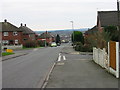
Longley Road, Sandford Hill
Longley Road, Sandford Hill, Longton, Stoke on Trent. This is looking across Longton and is typical of many housing estates built in the immediate post war era in the area.
Image: © Phil Eptlett
Taken: 30 Jan 2007
0.16 miles
3
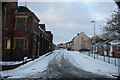
Middle Cross Street
Looking east from Caroline Street. On the left is the Longton Community Church. The blank gable to the right is the end of The Vine public house.
Image: © Alan Murray-Rust
Taken: 1 Dec 2010
0.18 miles
4
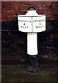
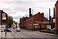
Old Milepost by the A5007, King Street, Stoke on Trent parish
Cast iron post by the A5007 (was A50), in parish of STOKE ON TRENT (STOKE ON TRENT District), West of Longton town centre, King Street, in tarmac in front of brick wall, on Southwest side of road. Cobridge iron casting, erected by the Newcastle to Blythe Marsh turnpike trust in the 19th century.
Inscription reads:-
: NEWCASTLE / 4 / MILES : : UTTOXETER / 14 / MILES :
Maker:-
: S.N. Cobridge :
Grade II listed.
List Entry Number: 1220531 https://historicengland.org.uk/listing/the-list/list-entry/1220531
Milestone Society National ID: ST_NCUT04.
Image: © J Higgins
Taken: 1 Jan 2000
0.18 miles
5
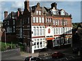
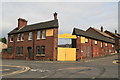
Crown Hotel, Longton
Original the Crown and Anchor Hotel and just next to the hotel (on the left) was St. John's Church.
This photo was taken from Longton Railway Station
Image: © Steven Birks
Taken: Unknown
0.18 miles
6
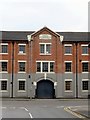
Pottery, King Street ,Longton.
Steven Birks describes this thus - Pottery works. Dated 1819, with later additions and modifications. Brick with plain tiled roofs. Entrance range of 3 storeys, 5 bays with central projecting bay with segmentally arched way to rear with Palladian style window over, and Diocletian window above. Pediment with heavy modillion cornice and date stone. Flat-arched windows in flanking sections, with continuous sill bands. Lower ranges of 2 storeys and 6 bays to left and right. Image
The sign on the end points to Regal Pottery so I suppose this may be that works. The building on the extreme left is Phoenix Pottery that retains two bottle ovens.
Image: © Chris Allen
Taken: 3 Mar 2012
0.19 miles
8
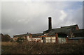
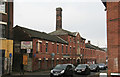
Boundary Works, Longton
This is a view from the rear of a part demolished works. The square brick chimney is typical of the area. The building dates from 1819 and was also known as the California works. The front may be seen here - Image
Image: © Chris Allen
Taken: 3 Mar 2012
0.19 miles
9
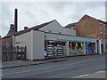
Portmeirion Factory Shop
Portmeirion Factory Shop on King Street in Longton.
Image: © Philip Halling
Taken: 21 Sep 2018
0.19 miles