IMAGES TAKEN NEAR TO
Strand Close, STOKE-ON-TRENT, ST2 9PG
Introduction
This page details the photographs taken nearby to Strand Close, ST2 9PG by members of the Geograph project.
The Geograph project started in 2005 with the aim of publishing, organising and preserving representative images for every square kilometre of Great Britain, Ireland and the Isle of Man.

There are currently over 7.5m images from over14,400 individuals and you can help contribute to the project by visiting https://www.geograph.org.uk
Image Map
Images are licensed for reuse under creativecommons.org/licenses/by-sa/2.0
Notes
- Clicking on the map will re-center to the selected point.
- The higher the marker number, the further away the image location is from the centre of the postcode.
Image Listing (4 Images Found)
Images are licensed for reuse under creativecommons.org/licenses/by-sa/2.0
Image
Details
Distance
1
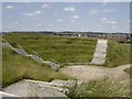
Berry Hill
Modern amphitheatre in area that used to be old mine workings now returned to grassland for the local community.
Image: © Andy Malbon
Taken: 13 Jul 2004
0.16 miles
2
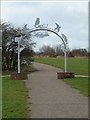
Metal Gateway - Sculpture by Phillip Hardaker
Location: Berryhill Greenway - cycleway at entrance to park nearest to Wadebridge Road
Installed: 2000
Commissioned by: Stoke on Trent City Council
Three gateways were constructed (Stone, timber and metal). The Metal Gateway is the furthest of the three Gateways from the Scheduled Ancient Monument, and thus reflects the most recent activity, namely mining and modern industry, in the area. The use of metal was part of the brief in that the material reflected the stage of human development on the site during its period as a centre of industrial activity.
This grey steel archway stands on two circular brick plinths either side of the path at one of the entrances into Berryhill Fields. It is decorated with animals and birds to be seen in the local area.
Two rabbits appear on either side of the arch, while along the top of the arch from left to right are a snail, two birds either side of an owl and a fish. A bat hangs from below the archway.
Image: © Steven Birks
Taken: Unknown
0.16 miles
3
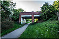
Disused Railway Line Bridge , Eaton park
Very near to where the Ubberley Colliery would have been on the disused Railway line of the Longton, Adderley Green and Bucknall Railway. Opened 1875 and Closed 1964. It was only a mineral line, removing coal from the five collieries on its 4.5 mile route.
Park Hall >>> http://www.thepotteries.org/mining/allmines/park_hall.htm
Adderley Green >>> http://www.thepotteries.org/mining/allmines/adderley_green.htm
Mossfields >>> http://www.thepotteries.org/mining/allmines/mossfield.htm
Ubberley >>> http://www.thepotteries.org/mining/allmines/ubberley.htm
Mossfield >>> http://www.thepotteries.org/mining/allmines/mossfield_longton.htm
It now forms a Pathway along most of the 4.5 miles.
Image: © Brian Deegan
Taken: 20 May 2020
0.17 miles
4
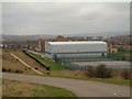
Berry Hill High School
Picture taken from nearby Berry Hill fields.
Image: © Steven Birks
Taken: 21 Jan 2006
0.18 miles