IMAGES TAKEN NEAR TO
Whitehouse Road, STOKE-ON-TRENT, ST2 8HJ
Introduction
This page details the photographs taken nearby to Whitehouse Road, ST2 8HJ by members of the Geograph project.
The Geograph project started in 2005 with the aim of publishing, organising and preserving representative images for every square kilometre of Great Britain, Ireland and the Isle of Man.

There are currently over 7.5m images from over14,400 individuals and you can help contribute to the project by visiting https://www.geograph.org.uk
Image Map
Images are licensed for reuse under creativecommons.org/licenses/by-sa/2.0
Notes
- Clicking on the map will re-center to the selected point.
- The higher the marker number, the further away the image location is from the centre of the postcode.
Image Listing (20 Images Found)
Images are licensed for reuse under creativecommons.org/licenses/by-sa/2.0
Image
Details
Distance

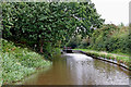
4
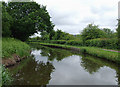
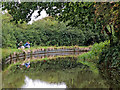
Caldon Canal north of Bucknall, Stoke-on-Trent
The River Trent meanders by about fifty metres off to the right, behind the hedge.
Image: © Roger D Kidd
Taken: 27 May 2011
0.23 miles
5
Cruising on The Caldon Canal near Stoke-on-Trent
Looking north as the Caldon Canal meanders towards Milton, Stockton Brook, Endon, Cheddleton and Froghall. The canal passes through a long strip of deciduous woodland which includes the track bed of the disused railway between Caldon Low and Stoke (off to the left), and the slopes down to the River Trent (off to the right).
Image: © Roger Kidd
Taken: 12 Sep 2019
0.23 miles
6
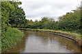
Caldon Canal near Abbey Hulton, Stoke-on-Trent
Looking south. The canal leads south-west towards Stoke-on-Trent.
Image: © Roger Kidd
Taken: 15 Sep 2019
0.23 miles
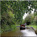
7
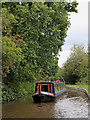
Narrowboat near Abbey Hulton, Stoke-on-Trent
Looking north as the Caldon Canal meanders towards Milton, Stockton Brook, Endon, Cheddleton and Froghall.
The 55 foot long narrowboat 'Pompey Chimes' is a long way from its home on the River Wey. The boat displays the coat of arms of the City of Portsmouth.
Image: © Roger Kidd
Taken: 12 Sep 2019
0.23 miles
8
Caldon Canal east of Birches Head, Stoke-on-Trent
Looking north-east as the Caldon Canal meanders towards Milton, Stockton Brook, Endon, Cheddleton and Froghall.
Image: © Roger Kidd
Taken: 12 Sep 2019
0.24 miles
9
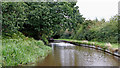
Caldon Canal east of Birches Head, Stoke-on-Trent
Looking north as the Caldon Canal meanders towards Milton, Stockton Brook, Endon, Cheddleton and Froghall. The canal passes through a long strip of deciduous woodland which includes the track bed of the disused railway between Caldon Low and Stoke (off to the left), and the slopes down to the River Trent (off to the right).
Image: © Roger Kidd
Taken: 12 Sep 2019
0.24 miles
10
Canal near Abbey Hulton, Stoke-on-Trent
Looking north as the Caldon Canal meanders towards Milton, Stockton Brook, Endon, Cheddleton and Froghall. The canal passes through a long strip of deciduous woodland which includes the track bed of the disused railway between Caldon Low and Stoke (off to the left), and the slopes down to the River Trent (off to the right).
Image: © Roger Kidd
Taken: 12 Sep 2019
0.24 miles