IMAGES TAKEN NEAR TO
Eaveswood Road, STOKE-ON-TRENT, ST2 8ER
Introduction
This page details the photographs taken nearby to Eaveswood Road, ST2 8ER by members of the Geograph project.
The Geograph project started in 2005 with the aim of publishing, organising and preserving representative images for every square kilometre of Great Britain, Ireland and the Isle of Man.

There are currently over 7.5m images from over14,400 individuals and you can help contribute to the project by visiting https://www.geograph.org.uk
Image Map
Images are licensed for reuse under creativecommons.org/licenses/by-sa/2.0
Notes
- Clicking on the map will re-center to the selected point.
- The higher the marker number, the further away the image location is from the centre of the postcode.
Image Listing (4 Images Found)
Images are licensed for reuse under creativecommons.org/licenses/by-sa/2.0
Image
Details
Distance
1
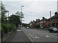
Greasley Road, Abbey Hulton
Looking south along Greasley Road. On the left of the photo is what was perhaps once a pub sign: the fairly new houses behind it may have replaced a pub.
Image: © David Weston
Taken: 24 Jul 2013
0.12 miles
2

Social club, Abbey Hulton
Abbey Hulton Suburban Club, on Greasley Road. The club's name is on the two large buildings, centre and right. To the left are small shops.
Image: © David Weston
Taken: 24 Jul 2013
0.13 miles
3
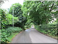
Eaves Lane, Abbey Hulton
The countryside near Abbey Hulton; in the distance is the edge of the residential area.
Image: © David Weston
Taken: 24 Jul 2013
0.18 miles
4
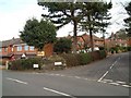
Housing at Eaves Lane, Abbey Hulton
Corner of Eaves Lane (to the right) and Greasely Road.
Image: © Steven Birks
Taken: 15 Feb 2007
0.20 miles