IMAGES TAKEN NEAR TO
Friars Road, STOKE-ON-TRENT, ST2 8DQ
Introduction
This page details the photographs taken nearby to Friars Road, ST2 8DQ by members of the Geograph project.
The Geograph project started in 2005 with the aim of publishing, organising and preserving representative images for every square kilometre of Great Britain, Ireland and the Isle of Man.

There are currently over 7.5m images from over14,400 individuals and you can help contribute to the project by visiting https://www.geograph.org.uk
Image Map
Images are licensed for reuse under creativecommons.org/licenses/by-sa/2.0
Notes
- Clicking on the map will re-center to the selected point.
- The higher the marker number, the further away the image location is from the centre of the postcode.
Image Listing (8 Images Found)
Images are licensed for reuse under creativecommons.org/licenses/by-sa/2.0
Image
Details
Distance
1
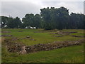
Hulton Abbey, Abbey Hulton
https://en.wikipedia.org/wiki/Hulton_Abbey
Image: © Brian Deegan
Taken: 19 Jul 2017
0.08 miles
2
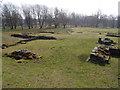
Ruins of Hulton Abbey
All that remains of the abbey that was dissolved in 1538. See http://en.wikipedia.org/wiki/Hulton_Abbey for further details.
Image: © Chris Beaver
Taken: 19 Mar 2015
0.09 miles
3
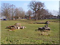
Ruined foundations of Hulton Abbey
All that remains of Hulton Abbey which was dissolved in 1538. See http://en.wikipedia.org/wiki/Hulton_Abbey for further details.
Image: © Chris Beaver
Taken: 19 Mar 2015
0.09 miles
4
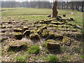
Random blocks of stone from Hulton Abbey remains
Cut and shaped stone blocks found around the site during the 1980s excavations of the remains of Hulton Abbey.
See the foundations Image and Image
The Abbey was dissolved in 1538.
Image: © Chris Beaver
Taken: 19 Mar 2015
0.10 miles
5
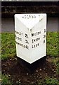
Old Milepost by the A5009, Leek Road, Stoke on Trent Parish
Cast iron post by the A5009, in parish of STOKE ON TRENT (STOKE ON TRENT District), between Milton and Abbey Hulton, behind tarmac path on grass, on East side of road. Lathe iron casting, erected by the County Council in the 19th/20th century.
Inscription reads:- : HANLEY 2¼ / STOKE 3¼ / NEWCASTLE 4¾ : : ABBEY / HULTON : : MILTON ¾ / ENDON 3½ / LEEK 8 : : Chas. Lathe, Tipton. :
Milestone Society National ID: ST_LKSK08.
Image: © J Higgins
Taken: 1 Jan 2000
0.18 miles
6
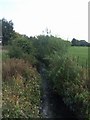
River Trent downstream of Abbey Farm
The waft of sewage treatment hangs in the air. The river has entered the Waterside Park. The City Council is making an attempt to make something of the river from which the city takes its name.
Image: © John M
Taken: 20 Sep 2009
0.20 miles
7
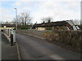
Bridge near Abbey Hulton
Bridge over the river Trent, on Birches Head Road near the junction with Leek Road.
Image: © David Weston
Taken: 21 Feb 2014
0.22 miles
8
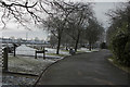
Carmountside Cemetery
On the last day of January with snow and frost on the ground the rows of headstones have the look of people standing to attention.
Image: © Malcolm Neal
Taken: 31 Jan 2019
0.23 miles