IMAGES TAKEN NEAR TO
Northfleet Street, STOKE-ON-TRENT, ST2 8AA
Introduction
This page details the photographs taken nearby to Northfleet Street, ST2 8AA by members of the Geograph project.
The Geograph project started in 2005 with the aim of publishing, organising and preserving representative images for every square kilometre of Great Britain, Ireland and the Isle of Man.

There are currently over 7.5m images from over14,400 individuals and you can help contribute to the project by visiting https://www.geograph.org.uk
Image Map
Images are licensed for reuse under creativecommons.org/licenses/by-sa/2.0
Notes
- Clicking on the map will re-center to the selected point.
- The higher the marker number, the further away the image location is from the centre of the postcode.
Image Listing (15 Images Found)
Images are licensed for reuse under creativecommons.org/licenses/by-sa/2.0
Image
Details
Distance
2
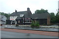
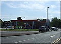
Bucknall China
Chinese restaurant in a former public house on Werrington Road
Image: © JThomas
Taken: 20 Jun 2015
0.08 miles
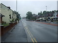
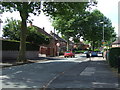
3
Ruxley Road, Bucknall
Looking west along Ruxley Road, and beyond towards Hanley.
Image: © David Weston
Taken: 19 Jun 2017
0.16 miles
4
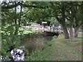
River Trent in Bucknall Park
The park houses the City Farm. Despite recent E-Coli fears there were no shortage of families out petting the animals.
Image: © John M
Taken: 20 Sep 2009
0.18 miles
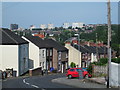
5
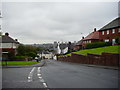
Looking west down Ruxley Road, Bucknall
Image: © Eirian Evans
Taken: 26 Sep 2012
0.18 miles
7
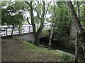
River Trent leaving Bucknall Park
The road bridge has been widened on this side.
Image: © John M
Taken: 20 Sep 2009
0.19 miles
8
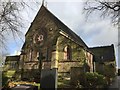
The Church Of St. Mary The Virgin, Bucknall (2017)
A glorious church with a substantial amount of history. There have been at least 3 churches recorded to have been present on the site. The first church built here is believed to be a timber-framed church, which was replaced by the second church - built in 1718. This church is known to have incorporated parts of Hulton Abbey. It then became a parish church in 1807 and later demolished to become the third church which still stands today, which was built in 1856. The parts of Hulton Abbey were lost when the second church was demolished, but the site holds a lot of history. There have been underground links to the Red Lion pub on Ruxley Road, which was a previous courthouse, and also has links to Bucknall House (now demolished). The church that stands today is over 150 years old, it is well maintained and has recently undergone a renovation inside which has certainly modernised the church's interior.
Image: © Samuel Bateman
Taken: 25 Nov 2017
0.22 miles
10
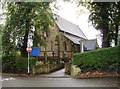
St Mary's Church, Bucknall
The Church of St Mary the Virgin is situated in Marychurch Lane, Bucknall, Stoke on Trent, and is one of three churches which form the Bucknall Team Ministry.
Image: © Eirian Evans
Taken: 26 Sep 2012
0.22 miles