IMAGES TAKEN NEAR TO
Leek New Road, STOKE-ON-TRENT, ST2 7HY
Introduction
This page details the photographs taken nearby to Leek New Road, ST2 7HY by members of the Geograph project.
The Geograph project started in 2005 with the aim of publishing, organising and preserving representative images for every square kilometre of Great Britain, Ireland and the Isle of Man.

There are currently over 7.5m images from over14,400 individuals and you can help contribute to the project by visiting https://www.geograph.org.uk
Image Map
Images are licensed for reuse under creativecommons.org/licenses/by-sa/2.0
Notes
- Clicking on the map will re-center to the selected point.
- The higher the marker number, the further away the image location is from the centre of the postcode.
Image Listing (12 Images Found)
Images are licensed for reuse under creativecommons.org/licenses/by-sa/2.0
Image
Details
Distance
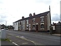
1
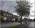
Bus shelter on A53, Leek New Road, Baddeley Green
The tree and shelter hide the traffic speed camera on its pillar just past the shelter.
Image: © David Smith
Taken: 1 Sep 2017
0.06 miles
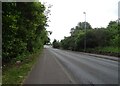
3
River Trent downstream of Leek Road
Position shown on OS mapping appears to be a flood channel.
Image: © John M
Taken: 20 Sep 2009
0.23 miles
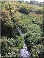
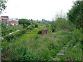
4
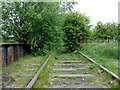
Disused railway track bed near Milton, Stoke-on-Trent
A glimpse of the rails, which have never been removed, can be seen near the top right corner of the image.
This is the former North Staffordshire Railway line from Leek and Cauldon Low looking towards Cauldon Low. The line was opened in 1867, and the last freight was carried in 1988. Passenger service ceased in 1965. The track has never been taken up, and the route has recently been purchased by the Moorland and City Railways Company, who have already opened part of the line to Cauldon Low Quarry, and hope to join the main line at Stoke, thus reopening the line here at Milton.
Image: © Roger D Kidd
Taken: 27 May 2011
0.23 miles
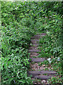
5
By the disused railway near Milton, Stoke-on-Trent
The track bed is on the right, rails concealed, but still in place looking towards Endon and Cauldon Low. The Caldon Canal (opened in 1779) is on the left, with new housing built circa 2008. The meadows are part of the River Trent floodplain. Image]
The former North Staffordshire Railway line from Leek and Cauldon Low was opened in 1867, and the last freight was carried in 1988. Passenger service ceased in 1965. The track has never been taken up, and the route has recently been purchased by the Moorland and City Railways Company, who have already opened part of the line to Cauldon Low Quarry, and hope to join the main line at Stoke, thus reopening the line here at Milton.
Image: © Roger D Kidd
Taken: 27 May 2011
0.23 miles
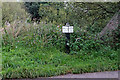
8
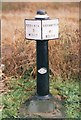
Old milemarker by the Caldon Canal, Milton
Milemarker by the Caldon Canal, in parish of Stoke on Trent (Stoke on Trent District), North of the A53, by Northeast abutment of railway bridge.
Inscription reads:-
: ETRURIA / 5 / MILES : : UTTOXETER / 25 / MILES :
Maker:-
: C / 19 81 / CS :
(Caldon Canal Society)
Surveyed
Milestone Society National ID: CAL-05R
Image: © Milestone Society
Taken: Unknown
0.25 miles
9
Disused railway near Milton, Stoke-on-Trent
The track crossing the Caldon Canal at canal Bridge No 19A.
This is the former North Staffordshire Railway line from Leek and Cauldon Low looking towards Cauldon Low. The line was opened in 1867, and the last freight was carried in 1988. Passenger service ceased in 1965. The track has never been taken up, and the route has recently been purchased by the Moorland and City Railways Company, who have already opened part of the line to Cauldon Low Quarry, and hope to join the main line at Stoke, thus reopening the line here at Milton.
Image: © Roger D Kidd
Taken: 27 May 2011
0.25 miles
10
Canal milemarker near Milton in Stoke-on-Trent
This is by the Caldon Canal north of the railway bridge, No 19A. The mile marker is a replica, dated 1981.
Image: © Roger Kidd
Taken: 12 Sep 2019
0.25 miles