IMAGES TAKEN NEAR TO
Field Avenue, STOKE-ON-TRENT, ST2 7AN
Introduction
This page details the photographs taken nearby to Field Avenue, ST2 7AN by members of the Geograph project.
The Geograph project started in 2005 with the aim of publishing, organising and preserving representative images for every square kilometre of Great Britain, Ireland and the Isle of Man.

There are currently over 7.5m images from over14,400 individuals and you can help contribute to the project by visiting https://www.geograph.org.uk
Image Map
Images are licensed for reuse under creativecommons.org/licenses/by-sa/2.0
Notes
- Clicking on the map will re-center to the selected point.
- The higher the marker number, the further away the image location is from the centre of the postcode.
Image Listing (4 Images Found)
Images are licensed for reuse under creativecommons.org/licenses/by-sa/2.0
Image
Details
Distance
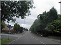
1
House of Horrors
A dishevelled property in one of the suburbs of Stoke-on-Trent.
Image: © Stu JP
Taken: 25 Jun 2015
0.04 miles
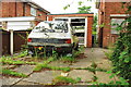
2
Path No 58, west of Baddeley Edge leading to Netherton Grove
Image: © Colin Park
Taken: 6 Feb 2020
0.15 miles
3
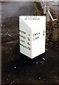
Old Milepost by the A5009, Baddeley Green Lane, Baddeley Green
Cast iron post by the A5009, in parish of STOKE ON TRENT (STOKE ON TRENT District), between Milton and Baddeley Green, in tarmac path against wall, on East side of road. Lathe iron casting, erected by the County Council in the 19th/20th century.
Inscription reads:-
: MILTON ¼ / HANLEY 3¼ / STOKE 4¼ / NEWCASTLE 5¾ : : NORTON / IN THE MOORS : : ENDON 2½ / LEEK 7 :
Maker:-
: Chas. Lathe, Tipton.
Milestone Society National ID: ST_LKSK07.
Image: © J Higgins
Taken: 1 Jan 2000
0.15 miles