IMAGES TAKEN NEAR TO
Station Road, STAFFORD, ST21 6RS
Introduction
This page details the photographs taken nearby to Station Road, ST21 6RS by members of the Geograph project.
The Geograph project started in 2005 with the aim of publishing, organising and preserving representative images for every square kilometre of Great Britain, Ireland and the Isle of Man.

There are currently over 7.5m images from over14,400 individuals and you can help contribute to the project by visiting https://www.geograph.org.uk
Image Map
Images are licensed for reuse under creativecommons.org/licenses/by-sa/2.0
Notes
- Clicking on the map will re-center to the selected point.
- The higher the marker number, the further away the image location is from the centre of the postcode.
Image Listing (13 Images Found)
Images are licensed for reuse under creativecommons.org/licenses/by-sa/2.0
Image
Details
Distance
4
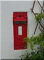
Disused Victorian postbox, Mill Meece Marsh, Cotes Heath
See Image] for context.
Image: © JThomas
Taken: 1 Jun 2019
0.10 miles
5
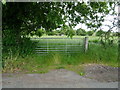
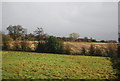
Field entrance off Mill Meece Marsh, Cotes Heath
Image: © JThomas
Taken: 1 Jun 2019
0.10 miles
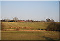
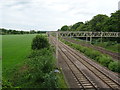
7
Mill Meece Marsh, Cotes Heath
Looking south east beside the West Coast Main Line.
Image: © JThomas
Taken: 1 Jun 2019
0.12 miles
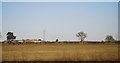
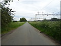
9
West Coast Main Line, Cotes Heath
Looking north from the bridge on Mill Lnae.
Image: © JThomas
Taken: 1 Jun 2019
0.15 miles