IMAGES TAKEN NEAR TO
Slindon, STAFFORD, ST21 6QP
Introduction
This page details the photographs taken nearby to ST21 6QP by members of the Geograph project.
The Geograph project started in 2005 with the aim of publishing, organising and preserving representative images for every square kilometre of Great Britain, Ireland and the Isle of Man.

There are currently over 7.5m images from over14,400 individuals and you can help contribute to the project by visiting https://www.geograph.org.uk
Image Map
Images are licensed for reuse under creativecommons.org/licenses/by-sa/2.0
Notes
- Clicking on the map will re-center to the selected point.
- The higher the marker number, the further away the image location is from the centre of the postcode.
Image Listing (2 Images Found)
Images are licensed for reuse under creativecommons.org/licenses/by-sa/2.0
Image
Details
Distance
1
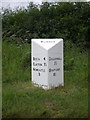
A new milepost beside the A519
A new milepost, only cast in 2010, has been placed to replace the lost original at this location on the outside of the bend just north of Slindon. In the last year or so, I've noticed another newly-cast post Image about 4 miles away, and a couple of others that seem to have reappeared after a long priod missing. Looks like someone is taking a close interest in the history of this route.
Image: © Richard Law
Taken: 19 Jun 2011
0.04 miles