IMAGES TAKEN NEAR TO
Chebsey, STAFFORD, ST21 6ND
Introduction
This page details the photographs taken nearby to ST21 6ND by members of the Geograph project.
The Geograph project started in 2005 with the aim of publishing, organising and preserving representative images for every square kilometre of Great Britain, Ireland and the Isle of Man.

There are currently over 7.5m images from over14,400 individuals and you can help contribute to the project by visiting https://www.geograph.org.uk
Image Map
Images are licensed for reuse under creativecommons.org/licenses/by-sa/2.0
Notes
- Clicking on the map will re-center to the selected point.
- The higher the marker number, the further away the image location is from the centre of the postcode.
Image Listing (6 Images Found)
Images are licensed for reuse under creativecommons.org/licenses/by-sa/2.0
Image
Details
Distance
2
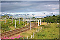
Main Line at Heamies
West Coast Main Line at Heamies Farm.
Image: © Wayland Smith
Taken: 18 Jul 2008
0.12 miles
3
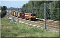
Southbound Intermodal service
A Trafford Park - Dollands Moor for the tunnel service at Heamies farm bridge. Colourful units on the train.
Image: © roger geach
Taken: 8 Sep 2004
0.13 miles
4
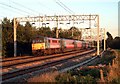
Evening light
A northbound express from Euston heads away from Heamies Farm just before the sun went down.
Image: © roger geach
Taken: 16 Sep 2003
0.20 miles