IMAGES TAKEN NEAR TO
Chiltern Lane, STAFFORD, ST21 6JJ
Introduction
This page details the photographs taken nearby to Chiltern Lane, ST21 6JJ by members of the Geograph project.
The Geograph project started in 2005 with the aim of publishing, organising and preserving representative images for every square kilometre of Great Britain, Ireland and the Isle of Man.

There are currently over 7.5m images from over14,400 individuals and you can help contribute to the project by visiting https://www.geograph.org.uk
Image Map
Images are licensed for reuse under creativecommons.org/licenses/by-sa/2.0
Notes
- Clicking on the map will re-center to the selected point.
- The higher the marker number, the further away the image location is from the centre of the postcode.
Image Listing (6 Images Found)
Images are licensed for reuse under creativecommons.org/licenses/by-sa/2.0
Image
Details
Distance
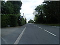

3

Roundabout on Stafford Road, Eccleshall
The A5013.
Image: © JThomas
Taken: 7 Sep 2019
0.18 miles
4

New housing development off Stafford Road, Eccleshall
Image: © JThomas
Taken: 7 Sep 2019
0.19 miles
5
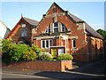
Eccleshall's Methodist Church
Built, according to the stone on the porch, in 1912
Image: © Richard Law
Taken: 15 Jul 2009
0.21 miles
6
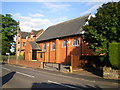
Eccleshall's Catholic Church
The Church of the Sacred Heart in Eccleshall
Image: © Richard Law
Taken: 15 Jul 2009
0.22 miles