IMAGES TAKEN NEAR TO
Eccleshall, STAFFORD, ST21 6JA
Introduction
This page details the photographs taken nearby to ST21 6JA by members of the Geograph project.
The Geograph project started in 2005 with the aim of publishing, organising and preserving representative images for every square kilometre of Great Britain, Ireland and the Isle of Man.

There are currently over 7.5m images from over14,400 individuals and you can help contribute to the project by visiting https://www.geograph.org.uk
Image Map
Images are licensed for reuse under creativecommons.org/licenses/by-sa/2.0
Notes
- Clicking on the map will re-center to the selected point.
- The higher the marker number, the further away the image location is from the centre of the postcode.
Image Listing (8 Images Found)
Images are licensed for reuse under creativecommons.org/licenses/by-sa/2.0
Image
Details
Distance
1
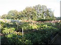
Johnson Nurseries
A Victorian walled garden, once a part of Johnson Hall and now a local nursery.
Image: © Anne Pollitt
Taken: 29 Oct 2006
0.09 miles
2
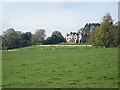
Johnson Hall
A view of Johnson Hall from the A519 Newport to Eccleshall road
Image: © Anne Pollitt
Taken: 29 Oct 2006
0.13 miles
3
Bishop Lonsdale Church of England Primary Academy
Image: © JThomas
Taken: 14 Mar 2020
0.18 miles
4
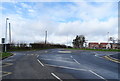
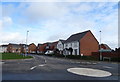
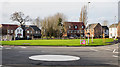
Roundabout on Shaws' Lane, Eccleshall
Serves a new housing estate on the edge of town.
Image: © JThomas
Taken: 14 Mar 2020
0.20 miles
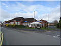
5
Houses on Overton Close, Eccleshall
New houses on the edge of town.
Image: © JThomas
Taken: 14 Mar 2020
0.22 miles
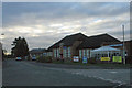
7
Housing beyond mini-roundabout
New housing at the south-western quarter of Eccleshall.
Image: © Trevor Littlewood
Taken: 23 Feb 2020
0.24 miles
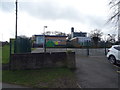
8
Eccleshall Community Centre
On Shaws' Lane.
Image: © JThomas
Taken: 14 Mar 2020
0.25 miles