IMAGES TAKEN NEAR TO
Church Street, STAFFORD, ST21 6EH
Introduction
This page details the photographs taken nearby to Church Street, ST21 6EH by members of the Geograph project.
The Geograph project started in 2005 with the aim of publishing, organising and preserving representative images for every square kilometre of Great Britain, Ireland and the Isle of Man.

There are currently over 7.5m images from over14,400 individuals and you can help contribute to the project by visiting https://www.geograph.org.uk
Image Map
Images are licensed for reuse under creativecommons.org/licenses/by-sa/2.0
Notes
- Clicking on the map will re-center to the selected point.
- The higher the marker number, the further away the image location is from the centre of the postcode.
Image Listing (69 Images Found)
Images are licensed for reuse under creativecommons.org/licenses/by-sa/2.0
Image
Details
Distance
1
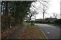
Chester Road, Eccleshall
Near Elford Heath heading west.
Image: © David Howard
Taken: 19 Jun 2022
0.02 miles
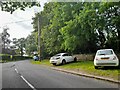
2
Entering Eccleshall on the B5026 from Croxton
Image: © Mick Malpass
Taken: 1 Dec 2011
0.03 miles
3
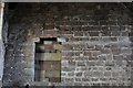
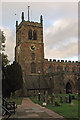
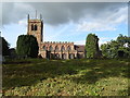
Eccleshall, Holy Trinity Church: The west wall showing the original roof position
Image: © Michael Garlick
Taken: 4 May 2019
0.11 miles
4
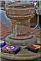
Eccleshall, Holy Trinity Church: c13th sandstone font
Image: © Michael Garlick
Taken: 4 May 2019
0.11 miles
5
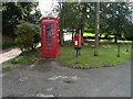
Elizabeth II postbox and telephone box on High Street, Eccleshall
Showing position of Postbox No. ST21 76.
See Image] for postbox.
Image: © JThomas
Taken: 7 Sep 2019
0.11 miles
7

Eccleshall, Holy Trinity Church: Nave capital 3
Image: © Michael Garlick
Taken: 4 May 2019
0.11 miles
8
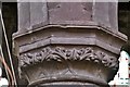
Eccleshall, Holy Trinity Church: Nave capital 2
Image: © Michael Garlick
Taken: 4 May 2019
0.11 miles
9

Eccleshall, Holy Trinity Church: Nave capital 1
Image: © Michael Garlick
Taken: 4 May 2019
0.11 miles