IMAGES TAKEN NEAR TO
Pear Place, STOKE-ON-TRENT, ST2 0TA
Introduction
This page details the photographs taken nearby to Pear Place, ST2 0TA by members of the Geograph project.
The Geograph project started in 2005 with the aim of publishing, organising and preserving representative images for every square kilometre of Great Britain, Ireland and the Isle of Man.

There are currently over 7.5m images from over14,400 individuals and you can help contribute to the project by visiting https://www.geograph.org.uk
Image Map
Images are licensed for reuse under creativecommons.org/licenses/by-sa/2.0
Notes
- Clicking on the map will re-center to the selected point.
- The higher the marker number, the further away the image location is from the centre of the postcode.
Image Listing (7 Images Found)
Images are licensed for reuse under creativecommons.org/licenses/by-sa/2.0
Image
Details
Distance
4
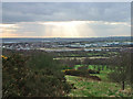
View from car park
A good viewpoint of Stoke on Trent from country park car park.
Image: © charles c
Taken: 17 Mar 2008
0.18 miles
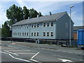
5

Willfield Conference Centre
Was part of Willfield School - Lauder Place North, Off Beverley Drive Bentilee.
Now houses: Willfield Neighbourhood College; Willfield Conference Centre; Willfield Youth Club; Bentilee Volunteers Office.
Image: © Steven Birks
Taken: 11 Feb 2007
0.22 miles
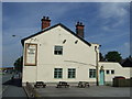
6
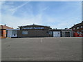
Berryhill Working Men's Club, Bentilee
Viewed from Calvary Crescent.
Image: © David Weston
Taken: 4 Jul 2019
0.23 miles
7
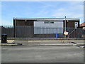
Berryhill Working Men's Club, Bentilee
The back of the building, seen from Dawlish Drive.
Image: © David Weston
Taken: 4 Jul 2019
0.23 miles