IMAGES TAKEN NEAR TO
Tally Close, STOKE-ON-TRENT, ST2 0SR
Introduction
This page details the photographs taken nearby to Tally Close, ST2 0SR by members of the Geograph project.
The Geograph project started in 2005 with the aim of publishing, organising and preserving representative images for every square kilometre of Great Britain, Ireland and the Isle of Man.

There are currently over 7.5m images from over14,400 individuals and you can help contribute to the project by visiting https://www.geograph.org.uk
Image Map
Images are licensed for reuse under creativecommons.org/licenses/by-sa/2.0
Notes
- Clicking on the map will re-center to the selected point.
- The higher the marker number, the further away the image location is from the centre of the postcode.
Image Listing (6 Images Found)
Images are licensed for reuse under creativecommons.org/licenses/by-sa/2.0
Image
Details
Distance
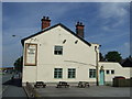
3
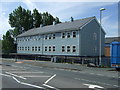
Berryhill Working Men's Club, Bentilee
Viewed from Calvary Crescent.
Image: © David Weston
Taken: 4 Jul 2019
0.18 miles
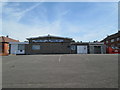
4
Berryhill Working Men's Club, Bentilee
The back of the building, seen from Dawlish Drive.
Image: © David Weston
Taken: 4 Jul 2019
0.20 miles
6
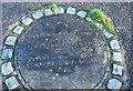
Fenton Park Miners' Poem (off Dividy Road)
Situated behind Hall Hill Drive is a park with this concrete plaque, which reads: There's black ash beneath the green, gob fires burning under Gas Hill, And beneath it all, Bones of miners buried still.
It is a memorial to a fatal gas explosion in 1889, which killed 64 miners.
Stoke on Trent used to be a major mining industry in many of its six towns.
Image: © Stu JP
Taken: 20 Dec 2015
0.25 miles