IMAGES TAKEN NEAR TO
Leicester Place, STOKE-ON-TRENT, ST2 0JR
Introduction
This page details the photographs taken nearby to Leicester Place, ST2 0JR by members of the Geograph project.
The Geograph project started in 2005 with the aim of publishing, organising and preserving representative images for every square kilometre of Great Britain, Ireland and the Isle of Man.

There are currently over 7.5m images from over14,400 individuals and you can help contribute to the project by visiting https://www.geograph.org.uk
Image Map
Images are licensed for reuse under creativecommons.org/licenses/by-sa/2.0
Notes
- Clicking on the map will re-center to the selected point.
- The higher the marker number, the further away the image location is from the centre of the postcode.
Image Listing (9 Images Found)
Images are licensed for reuse under creativecommons.org/licenses/by-sa/2.0
Image
Details
Distance
1
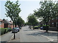
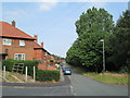
Beverley Drive, Bentilee
Residential area near Stoke-on-Trent. Looking along Beverley Drive, between the junctions with Maidstone Grove and Winchester Avenue.
Image: © David Weston
Taken: 18 Jul 2013
0.03 miles
2
St Maria Goretti Roman Catholic Church, Bentilee
Seen from Aylesbury Road. Further along, on the left of the photo, is the attached primary school.
Image: © David Weston
Taken: 18 Jul 2013
0.10 miles
3
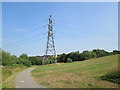
Electricity pylon near Beverley Drive, Bentilee
Along a footpath leading north from Beverley Drive. In the distance behind the pylon is Mitchell High School.
Image: © David Weston
Taken: 18 Jul 2013
0.13 miles
4
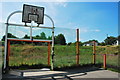
Basketball Court (Causeley Road, Townsend)
Sports pitch near to the closed Mitchell High School.
Image: © Stu JP
Taken: 9 Jul 2015
0.16 miles
5
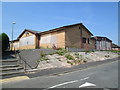
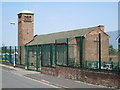
Disused social club, Bentilee
Ubberley & Bentilee Working Men's Club, seen from Aylesbury Road. The front of the building is on Ubberley Road, which runs parallel to this. It closed in 2010 because of funding difficulties.
Image: © David Weston
Taken: 18 Jul 2013
0.18 miles
6
Chelmsford Drive, Bentilee
Residential area near Stoke-on-Trent. Looking along Chelmsford Drive, from the junction with Oakham Way.
Image: © David Weston
Taken: 18 Jul 2013
0.19 miles
7
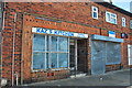
Kaz's Kitchen, Bucknall
Another abandoned business in the suburb of Stoke-on-Trent.
Image: © Stu JP
Taken: 16 Jul 2015
0.21 miles

9
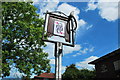
The Queen of Hearts, Lillydale Road, Bucknall
This pub has been abandoned for years.
Image: © Stu JP
Taken: 9 Jul 2015
0.24 miles