IMAGES TAKEN NEAR TO
Dividy Road, STOKE-ON-TRENT, ST2 0JB
Introduction
This page details the photographs taken nearby to Dividy Road, ST2 0JB by members of the Geograph project.
The Geograph project started in 2005 with the aim of publishing, organising and preserving representative images for every square kilometre of Great Britain, Ireland and the Isle of Man.

There are currently over 7.5m images from over14,400 individuals and you can help contribute to the project by visiting https://www.geograph.org.uk
Image Map
Images are licensed for reuse under creativecommons.org/licenses/by-sa/2.0
Notes
- Clicking on the map will re-center to the selected point.
- The higher the marker number, the further away the image location is from the centre of the postcode.
Image Listing (9 Images Found)
Images are licensed for reuse under creativecommons.org/licenses/by-sa/2.0
Image
Details
Distance
2
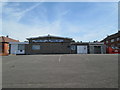
Berryhill Working Men's Club, Bentilee
Viewed from Calvary Crescent.
Image: © David Weston
Taken: 4 Jul 2019
0.12 miles
3
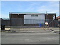
Berryhill Working Men's Club, Bentilee
The back of the building, seen from Dawlish Drive.
Image: © David Weston
Taken: 4 Jul 2019
0.13 miles
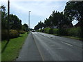
6
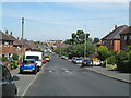
Dawlish Drive, Bentilee
Looking north-west, with the community centre in the far distance.
Image: © David Weston
Taken: 4 Jul 2019
0.18 miles
7
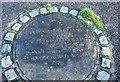
Fenton Park Miners' Poem (off Dividy Road)
Situated behind Hall Hill Drive is a park with this concrete plaque, which reads: There's black ash beneath the green, gob fires burning under Gas Hill, And beneath it all, Bones of miners buried still.
It is a memorial to a fatal gas explosion in 1889, which killed 64 miners.
Stoke on Trent used to be a major mining industry in many of its six towns.
Image: © Stu JP
Taken: 20 Dec 2015
0.23 miles
8
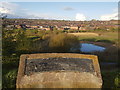
Lawn Farm Moated Site, Berryhill Fields
Lawn Farm moated site was created in the late 1200's by the Standon family, lords of the manor of Fenton Vivian. The site would have served as a manor house but might also have been used as a hunting lodge for the near-by deer park established by Robert of Standon in the 1280's. Although not their main residence, Lawn Farm would still have been of significant value to the family and a symbol of their social standing.
The Standon's had ceased to own the manor and moated site by the mid 1300's. It eventually passed to a lord who lived far from Lawn Farm and had little interest in the site. It had fallen into disrepair and been abandoned by the early 15th century.
On the site, archaeological excavations have uncovered remains of The Hall, an Oven (or Kiln), Circular Dovecote and a Fish Pond.
Image: © Brian Deegan
Taken: 25 Apr 2018
0.23 miles
9
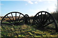
Colliery pithead wheels at Berryhill Fields, Fenton Park
These four wheels sit at the top of the spoil heap on what used to be Mossfield Colliery. All sides of the wheels feature nameplates that depict the coal seams of Mossfield Colliery: Bambury, Cockshead, Bowling Alley, Cottage, Berry Hill, Dole Pool, Deep Folly, First Ash, Hard Mine, Fenton Park, Lawn, Knowles, Moss Field, Marl Howle and Old Railway.
Image: © Stu JP
Taken: 20 Dec 2015
0.24 miles