IMAGES TAKEN NEAR TO
Wellfield Road, STOKE-ON-TRENT, ST2 0DP
Introduction
This page details the photographs taken nearby to Wellfield Road, ST2 0DP by members of the Geograph project.
The Geograph project started in 2005 with the aim of publishing, organising and preserving representative images for every square kilometre of Great Britain, Ireland and the Isle of Man.

There are currently over 7.5m images from over14,400 individuals and you can help contribute to the project by visiting https://www.geograph.org.uk
Image Map
Images are licensed for reuse under creativecommons.org/licenses/by-sa/2.0
Notes
- Clicking on the map will re-center to the selected point.
- The higher the marker number, the further away the image location is from the centre of the postcode.
Image Listing (9 Images Found)
Images are licensed for reuse under creativecommons.org/licenses/by-sa/2.0
Image
Details
Distance
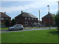
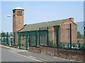
3
Disused social club, Bentilee
Ubberley & Bentilee Working Men's Club, seen from Aylesbury Road. The front of the building is on Ubberley Road, which runs parallel to this. It closed in 2010 because of funding difficulties.
Image: © David Weston
Taken: 18 Jul 2013
0.19 miles
4
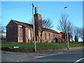
St. Stephens Church, Bentilee
Bentilee is situated approximately 2 miles east of Stoke-upon-Trent city centre.
The church is in Dawlish Drive just off the A5272 (B5040)
Image: © Steven Birks
Taken: 11 Feb 2007
0.19 miles
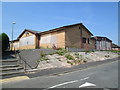
5
St Maria Goretti Roman Catholic Church, Bentilee
Seen from Aylesbury Road. Further along, on the left of the photo, is the attached primary school.
Image: © David Weston
Taken: 18 Jul 2013
0.20 miles

7
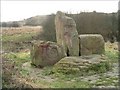
Stone Gateway - Sculpture by Peter Price
Location: Berryhill Greenway
Installed: 2000
Commissioned by: Stoke on Trent City Council
Three gateways were constructed (Stone, timber and metal). The Stone Gateway is the nearest to the Scheduled Ancient Monument, and was intended to commemorate the earliest history of the area before it was settled by farmers.
This explains the use of stone, the presence of the animals, the hunting scene, and possibly the standing figure in robes (it may be a monk or a nun). However, it cannot explain the depiction of the young girl in T-shirt and shorts, the man in the bobble hat, or the melting watch. The last of these could be an allusion to the idea of a time line.
Image: © Steven Birks
Taken: Unknown
0.22 miles
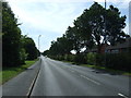
9
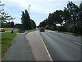
Bus stop on Dividy Road (A5272)
Looking south east.
Image: © JThomas
Taken: 12 Jul 2014
0.25 miles