IMAGES TAKEN NEAR TO
Wellfield Road, STOKE-ON-TRENT, ST2 0DD
Introduction
This page details the photographs taken nearby to Wellfield Road, ST2 0DD by members of the Geograph project.
The Geograph project started in 2005 with the aim of publishing, organising and preserving representative images for every square kilometre of Great Britain, Ireland and the Isle of Man.

There are currently over 7.5m images from over14,400 individuals and you can help contribute to the project by visiting https://www.geograph.org.uk
Image Map
Images are licensed for reuse under creativecommons.org/licenses/by-sa/2.0
Notes
- Clicking on the map will re-center to the selected point.
- The higher the marker number, the further away the image location is from the centre of the postcode.
Image Listing (9 Images Found)
Images are licensed for reuse under creativecommons.org/licenses/by-sa/2.0
Image
Details
Distance
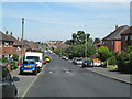
1
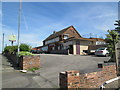
The Hollybush, Bentilee
The pub is a short way south-east of the shopping centre.
Image: © David Weston
Taken: 4 Jul 2019
0.09 miles
3
Demolished, The Thurston, Thurston Way
Image: © Alex McGregor
Taken: 7 Nov 2012
0.11 miles
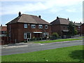
5
Dawlish Drive, Bentilee
Looking north-west, with the community centre in the far distance.
Image: © David Weston
Taken: 4 Jul 2019
0.13 miles
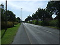
6
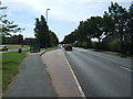
Bus stop on Dividy Road (A5272)
Looking south east.
Image: © JThomas
Taken: 12 Jul 2014
0.19 miles
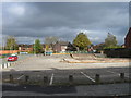
7

Bentilee Community Centre
A side view of the building, viewed from the north-west, beyond a grassy area and a tarmacked sports pitch.
Image: © David Weston
Taken: 4 Jul 2019
0.22 miles
8
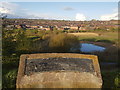
Lawn Farm Moated Site, Berryhill Fields
Lawn Farm moated site was created in the late 1200's by the Standon family, lords of the manor of Fenton Vivian. The site would have served as a manor house but might also have been used as a hunting lodge for the near-by deer park established by Robert of Standon in the 1280's. Although not their main residence, Lawn Farm would still have been of significant value to the family and a symbol of their social standing.
The Standon's had ceased to own the manor and moated site by the mid 1300's. It eventually passed to a lord who lived far from Lawn Farm and had little interest in the site. It had fallen into disrepair and been abandoned by the early 15th century.
On the site, archaeological excavations have uncovered remains of The Hall, an Oven (or Kiln), Circular Dovecote and a Fish Pond.
Image: © Brian Deegan
Taken: 25 Apr 2018
0.22 miles
9
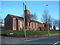
St. Stephens Church, Bentilee
Bentilee is situated approximately 2 miles east of Stoke-upon-Trent city centre.
The church is in Dawlish Drive just off the A5272 (B5040)
Image: © Steven Birks
Taken: 11 Feb 2007
0.23 miles