IMAGES TAKEN NEAR TO
Tring Close, STOKE-ON-TRENT, ST2 0AU
Introduction
This page details the photographs taken nearby to Tring Close, ST2 0AU by members of the Geograph project.
The Geograph project started in 2005 with the aim of publishing, organising and preserving representative images for every square kilometre of Great Britain, Ireland and the Isle of Man.

There are currently over 7.5m images from over14,400 individuals and you can help contribute to the project by visiting https://www.geograph.org.uk
Image Map
Images are licensed for reuse under creativecommons.org/licenses/by-sa/2.0
Notes
- Clicking on the map will re-center to the selected point.
- The higher the marker number, the further away the image location is from the centre of the postcode.
Image Listing (11 Images Found)
Images are licensed for reuse under creativecommons.org/licenses/by-sa/2.0
Image
Details
Distance
1
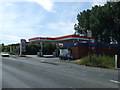
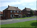
Demolished, The Thurston, Thurston Way
Image: © Alex McGregor
Taken: 7 Nov 2012
0.07 miles
2
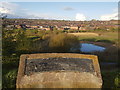
Lawn Farm Moated Site, Berryhill Fields
Lawn Farm moated site was created in the late 1200's by the Standon family, lords of the manor of Fenton Vivian. The site would have served as a manor house but might also have been used as a hunting lodge for the near-by deer park established by Robert of Standon in the 1280's. Although not their main residence, Lawn Farm would still have been of significant value to the family and a symbol of their social standing.
The Standon's had ceased to own the manor and moated site by the mid 1300's. It eventually passed to a lord who lived far from Lawn Farm and had little interest in the site. It had fallen into disrepair and been abandoned by the early 15th century.
On the site, archaeological excavations have uncovered remains of The Hall, an Oven (or Kiln), Circular Dovecote and a Fish Pond.
Image: © Brian Deegan
Taken: 25 Apr 2018
0.09 miles
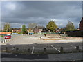
5
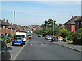
Dawlish Drive, Bentilee
Looking north-west, with the community centre in the far distance.
Image: © David Weston
Taken: 4 Jul 2019
0.21 miles
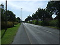
6
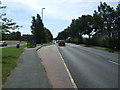
Bus stop on Dividy Road (A5272)
Looking south east.
Image: © JThomas
Taken: 12 Jul 2014
0.21 miles
7
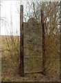
Timber Gateway panel by Anthony Hammond
Location: at Berryhill Greenway - at one of the entrances to the park nearest to Uffington Parade
Installed: 2000
Commissioned by: Stoke on Trent City Council
Three gateways were constructed (Stone, timber and metal). The Timber Gateway is the central Gateway and commemorates agriculture and early mining in the area before it became heavily industrialised.
The use of timber was part of the brief, in that it used a material that reflected the level of human development on the site at that time.
The wooden panel consists of six wooden planks supported between two upright wooden poles, with a circular roundel of a bird on the front face at the top. The bird is flanked by a flower and a bird. Below is a butterfly, flanked by a dragonfly and a flower. Beneath is an owl, another bird, and a heron. Below are several animals, including a rabbit, a hedgehog, a lizard and another bird. At the bottom of the panel are two working men, one a farm labourer with a scythe, the other a miner with pick and shovel.
The panel is intended both to commemorate the past history of the site and to celebrate the variety of wildlife found there today.
Image: © Steven Birks
Taken: Unknown
0.23 miles
8
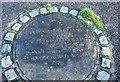
Fenton Park Miners' Poem (off Dividy Road)
Situated behind Hall Hill Drive is a park with this concrete plaque, which reads: There's black ash beneath the green, gob fires burning under Gas Hill, And beneath it all, Bones of miners buried still.
It is a memorial to a fatal gas explosion in 1889, which killed 64 miners.
Stoke on Trent used to be a major mining industry in many of its six towns.
Image: © Stu JP
Taken: 20 Dec 2015
0.23 miles
9
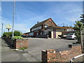
The Hollybush, Bentilee
The pub is a short way south-east of the shopping centre.
Image: © David Weston
Taken: 4 Jul 2019
0.23 miles