IMAGES TAKEN NEAR TO
Norbury Junction, STAFFORD, ST20 0PN
Introduction
This page details the photographs taken nearby to ST20 0PN by members of the Geograph project.
The Geograph project started in 2005 with the aim of publishing, organising and preserving representative images for every square kilometre of Great Britain, Ireland and the Isle of Man.

There are currently over 7.5m images from over14,400 individuals and you can help contribute to the project by visiting https://www.geograph.org.uk
Image Map
Images are licensed for reuse under creativecommons.org/licenses/by-sa/2.0
Notes
- Clicking on the map will re-center to the selected point.
- The higher the marker number, the further away the image location is from the centre of the postcode.
Image Listing (109 Images Found)
Images are licensed for reuse under creativecommons.org/licenses/by-sa/2.0
Image
Details
Distance
1
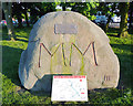
An erratic at Norbury Junction, Staffordshire
There are five large boulders placed on display in the Norbury area. This is number three. Each rock has a plaque with the following information:
THIS STONE IS ONE OF FIVE WHICH HAVE
BEEN ERECTED AROUND THE PARISH OF
NORBURY TO MARK THE YEAR A.D. 2000.
IT IS A GLACIAL BOULDER DEPOSITED IN
THIS NEIGHBOURHOOD AT THE END OF THE
LAST ICE AGE AROUND 10 MILLENNIA AGO.
THE STONES ARE SITED AT:-
I. NORBURY VILLAGE HALL II. OULTON
III. NORBURY JUNCTION IV. LOYNTON
V. WESTON JONES
Image: © Roger D Kidd
Taken: 23 May 2010
0.01 miles
2
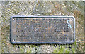
Plaque on an erratic at Norbury Junction, Staffordshire
There are five large boulders placed on display in the Norbury area. Each rock has a plaque such as this one, which is on rock number three.
Image
Image
Image
Image: © Roger D Kidd
Taken: 23 May 2010
0.01 miles
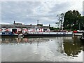
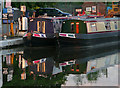
3
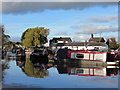
Norbury Junction
Located on the beautiful Shropshire Union Canal at the Junction of the now disused canal to Newport, Shropshire and beyond, this is an ideal cruising base for the famous Four Counties Ring, with convenient access to the Black Country ring, Llangollen canal and its famous Pontcysyllte aqueduct and the Staffs and Worcs canal with its terminus at Stourport.
Image: © Carol Walker
Taken: 13 Nov 2013
0.02 miles
4
Tea shop and chandlery
Try spotting the differences between this picture and Neil Clifton's taken in 1964. Image
Image: © John M
Taken: 21 Oct 2007
0.02 miles
5
Norbury Junction: The Old Wharf Tearoom and Gift Shop
Image: © Michael Garlick
Taken: 4 May 2019
0.02 miles
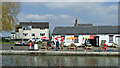
6
Norbury Junction wharf marina
On the Shropshire Union Canal.
Image: © Andrew Abbott
Taken: 12 Sep 2022
0.03 miles
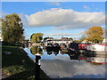
7
Norbury Junction wharf in Staffordshire
Shropshire Union Canal.
The Shrewsbury Canal, which was abandoned in 1944, branched off south-west, behind the camera. The short arm remaining is now used as a dry dock.
Image: © Roger Kidd
Taken: 20 Apr 2013
0.03 miles
8
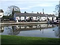
Moorings at Norbury Junction
The moorings are surrounded by acres of rural farmland, a network
of footpaths including the “Millennium Trail” and are within easy reach
of Stafford, Telford and the M6 motorway.
Image: © Carol Walker
Taken: 13 Nov 2013
0.03 miles
9
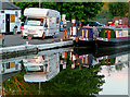
Reflections at Norbury Wharf, Staffordshire
Shropshire Union Canal.
The orange hues cast by the setting sun are beginning to show in this view of the wharf taken from the patio of The Junction Inn.
Image: © Roger D Kidd
Taken: 23 May 2010
0.03 miles
10
Evening hues at Norbury Wharf, Staffordshire
Shropshire Union Canal.
The orange hues cast by the setting sun are beginning to show in this view of the wharf taken from the patio of The Junction Inn.
Note: diesel 59.9p a litre. Tax is paid on top of that if the boat only uses it for propulsion. If it is used partly for heating and "domestic" on board, a part of it is taxed, and part is at the base "red" diesel price.
Image: © Roger D Kidd
Taken: 23 May 2010
0.03 miles