IMAGES TAKEN NEAR TO
Tunstall Lane, STAFFORD, ST20 0NQ
Introduction
This page details the photographs taken nearby to Tunstall Lane, ST20 0NQ by members of the Geograph project.
The Geograph project started in 2005 with the aim of publishing, organising and preserving representative images for every square kilometre of Great Britain, Ireland and the Isle of Man.

There are currently over 7.5m images from over14,400 individuals and you can help contribute to the project by visiting https://www.geograph.org.uk
Image Map
Images are licensed for reuse under creativecommons.org/licenses/by-sa/2.0
Notes
- Clicking on the map will re-center to the selected point.
- The higher the marker number, the further away the image location is from the centre of the postcode.
Image Listing (27 Images Found)
Images are licensed for reuse under creativecommons.org/licenses/by-sa/2.0
Image
Details
Distance
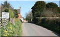
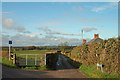
2
Lanes junction west of High Offley in Staffordshire
The very minor road on the right is Tunstall Lane, and is partly an unsurfaced byway. The main route leading west towards Knighton is named on some maps as High Offley Road.
Image: © Roger Kidd
Taken: 7 Jul 2014
0.02 miles
3
Not suitable for motor vehicles - southern end of Tunstall Lane
Image: © Row17
Taken: 22 Nov 2011
0.02 miles
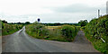
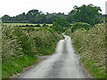
4

Tunstall Lane north-west of High Offley in Staffordshire
Looking north-west, this mainly unsurfaced byway leads to the hamlet of Tunstall.
Image: © Roger Kidd
Taken: 7 Jul 2014
0.06 miles
5
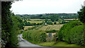
Farmland west of High Offley in Staffordshire
Some maps name this lane as High Offley Road. It leads westwards towards Knighton.
Image: © Roger Kidd
Taken: 7 Jul 2014
0.06 miles
6
Road west from High Offley in Staffordshire
Looking west towards Knighton from near the junction with Peggs Lane, some maps label this as High Offley Road.
Image: © Roger Kidd
Taken: 7 Jul 2014
0.06 miles
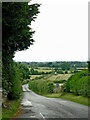
7
Lane west of High Offley in Staffordshire
The laneleading west towards Knighton is named on some maps as High Offley Road.
Image: © Roger Kidd
Taken: 7 Jul 2014
0.08 miles
8
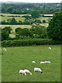
Staffordshire pasture near High Offley
A telephoto assisted image, looking west north west across fields from the footpath by St Mary's Church graveyard. The lane near The Claylands is marked as High Offley Road on some maps. Peggs Lane crosses the scene behind the hedge by the far sheep.
Image: © Roger Kidd
Taken: 7 Jul 2014
0.09 miles