IMAGES TAKEN NEAR TO
High Offley, STAFFORD, ST20 0NJ
Introduction
This page details the photographs taken nearby to ST20 0NJ by members of the Geograph project.
The Geograph project started in 2005 with the aim of publishing, organising and preserving representative images for every square kilometre of Great Britain, Ireland and the Isle of Man.

There are currently over 7.5m images from over14,400 individuals and you can help contribute to the project by visiting https://www.geograph.org.uk
Image Map
Images are licensed for reuse under creativecommons.org/licenses/by-sa/2.0
Notes
- Clicking on the map will re-center to the selected point.
- The higher the marker number, the further away the image location is from the centre of the postcode.
Image Listing (7 Images Found)
Images are licensed for reuse under creativecommons.org/licenses/by-sa/2.0
Image
Details
Distance
1
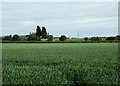
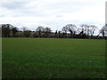
Looking towards Claylands
Seen across a field of wheat from the lane to Tunstall.
Image: © Simon Huguet
Taken: 12 Jun 2009
0.15 miles
5
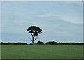
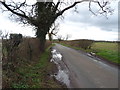
Lonely tree
Seen in a hedgerow across a field of wheat from the lane to Tunstall this tree looks to be dying back from the bottom.
Image: © Simon Huguet
Taken: 12 Jun 2009
0.22 miles
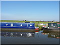
6
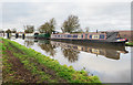
'Harriet Ann' with other boats
The narrow boat, 'Harriet Ann' is moored on the north side of the Shropshire Union Canal close to High Offley.
This part of the Shropshire Union was originally the Birmingham and Liverpool Junction Canal.
Image: © Trevor Littlewood
Taken: 25 Dec 2019
0.24 miles
7
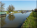
Canal and moorings near High Offley
The Shropshire Union canal and its towpath just clip the SW corner of this square, with a handful of longboats moored up for the winter.
Image: © Richard Law
Taken: 9 Mar 2014
0.24 miles