IMAGES TAKEN NEAR TO
Knightley Way, STAFFORD, ST20 0HX
Introduction
This page details the photographs taken nearby to Knightley Way, ST20 0HX by members of the Geograph project.
The Geograph project started in 2005 with the aim of publishing, organising and preserving representative images for every square kilometre of Great Britain, Ireland and the Isle of Man.

There are currently over 7.5m images from over14,400 individuals and you can help contribute to the project by visiting https://www.geograph.org.uk
Image Map
Images are licensed for reuse under creativecommons.org/licenses/by-sa/2.0
Notes
- Clicking on the map will re-center to the selected point.
- The higher the marker number, the further away the image location is from the centre of the postcode.
Image Listing (16 Images Found)
Images are licensed for reuse under creativecommons.org/licenses/by-sa/2.0
Image
Details
Distance
1
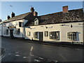
The Horns pub in Gnosall
Public house.
Image: © Jeremy Bolwell
Taken: 20 Jan 2022
0.18 miles
3
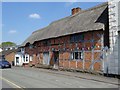
Timber-framed cottage
Timber-framed cottage with bricks inlaid in a herringbone style. The cottage is on High Street in Gnosall Heath.
Image: © Philip Halling
Taken: 19 May 2018
0.20 miles

6
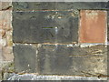
Ordnance Survey bolt on St Lawrence Church
This bench mark was established in 1858 during the First primary levelling, England & Wales, and was levelled with a height of 344.5180 feet [105.0091 metres] above mean sea level (Liverpool datum). It was included on the Llandysilio to Stafford levelling line. The surveyor's description was No. 98. Bolt in North-west angle of Gnosall Church ; 2.69 ft. above surface (p588).
Image: © Shantavira
Taken: 16 Aug 2013
0.23 miles
7
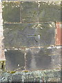
OS benchmark and bolt - Gnosall, St Lawrence's Church
A First Primary Levelling bolt and cutmark on the buttress of the church, levelled in late 1858 at 344' 6" above mean sea level at Liverpool datum. It was last verified for height in the 1950s at 104.874m above Ordnance Datum Newlyn.
Image: © Richard Law
Taken: 9 Apr 2016
0.23 miles
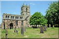
8
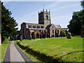
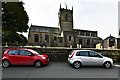
St Lawrence, Gnosall
Founded in the 11th century, this church has details from almost all periods of English architecture
Image: © Eirian Evans
Taken: 5 Jun 2006
0.23 miles
10
St Lawrence's church, Gnosall
Gnosall church is dedicated to St Lawrence and dates from the 12th century. The church is Grade I listed, see: https://historicengland.org.uk/listing/the-list/list-entry/1242645
Image: © Philip Halling
Taken: 19 May 2018
0.24 miles