IMAGES TAKEN NEAR TO
The Oaklands, STAFFORD, ST20 0BA
Introduction
This page details the photographs taken nearby to The Oaklands, ST20 0BA by members of the Geograph project.
The Geograph project started in 2005 with the aim of publishing, organising and preserving representative images for every square kilometre of Great Britain, Ireland and the Isle of Man.

There are currently over 7.5m images from over14,400 individuals and you can help contribute to the project by visiting https://www.geograph.org.uk
Image Map
Images are licensed for reuse under creativecommons.org/licenses/by-sa/2.0
Notes
- Clicking on the map will re-center to the selected point.
- The higher the marker number, the further away the image location is from the centre of the postcode.
Image Listing (7 Images Found)
Images are licensed for reuse under creativecommons.org/licenses/by-sa/2.0
Image
Details
Distance
2
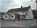
The Royal Oak
The only pub in the village, since the closure of The Swan further up near the church.
Image: © Richard Law
Taken: 3 Feb 2013
0.11 miles
3
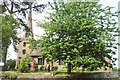
St Editha's Church, Church Eaton
The church, St Editha, is an ancient structure, in the Saxon style of architecture, with a low tower, supporting a spire of modern erection. The south side of the building likewise appears to have been rebuilt in modern times, from the square form of its windows.
Image: © Geoff Pick
Taken: 8 Jun 2004
0.15 miles
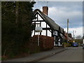
4
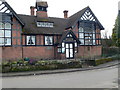
Church Eaton Village Institute
Mock-Tudor building actually built in 1892.
Image: © Eirian Evans
Taken: 26 Mar 2010
0.19 miles
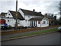
6
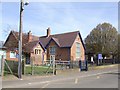
Church Eaton Endowed Primary School
Primary school in the main street in this small village.
Image: © John M
Taken: 6 Apr 2007
0.22 miles
7
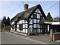
Briar Cottage
Traditional thatched cottage in the village main street.
Image: © John M
Taken: 6 Apr 2007
0.25 miles