IMAGES TAKEN NEAR TO
Eaton Green, STAFFORD, ST20 0AD
Introduction
This page details the photographs taken nearby to Eaton Green, ST20 0AD by members of the Geograph project.
The Geograph project started in 2005 with the aim of publishing, organising and preserving representative images for every square kilometre of Great Britain, Ireland and the Isle of Man.

There are currently over 7.5m images from over14,400 individuals and you can help contribute to the project by visiting https://www.geograph.org.uk
Image Map
Images are licensed for reuse under creativecommons.org/licenses/by-sa/2.0
Notes
- Clicking on the map will re-center to the selected point.
- The higher the marker number, the further away the image location is from the centre of the postcode.
Image Listing (15 Images Found)
Images are licensed for reuse under creativecommons.org/licenses/by-sa/2.0
Image
Details
Distance
1
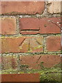
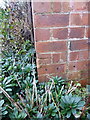
OS benchmark - Church Eaton, High Cottage
An OS cutmark on the gable wall of a roadside cottage near Church Eaton; originally levelled, probably in 1961, at 90.23m above Ordnance Datum Newlyn.
Image: © Richard Law
Taken: 23 Jan 2018
0.00 miles
2
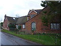
Buildings at Green Farm
The map of 1884 marks a 'Smithy' at this location, though the configuration of the buildings, and the style of the windows look rather more like a former school. By 1903, it's grown somewhat, and is described as Green Farm.
Image: © Richard Law
Taken: 23 Jan 2018
0.13 miles
3
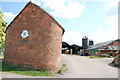
Green Farm, Church Eaton Green
The end of this barn has been built with rounded corners, which I have never seen before.
Image: © Mick Malpass
Taken: 30 Jul 2011
0.14 miles
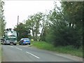
5
Cows and Silage, Green Farm from Woollaston Lane
Image: © Mick Malpass
Taken: 30 Jul 2011
0.17 miles
9
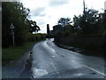
OS benchmark - Church Eaton, Laurels Cottage
An OS cutmark on the wall of a cottage at the junction of lanes. It was levelled, probably in 1961, at 88.959m above Ordnance Datum Newlyn, and appears to replace an earlier mark shown on maps from 1900 until 1924 at 292' 7" at the other end of the house.
Image: © Richard Law
Taken: 23 Jan 2018
0.19 miles
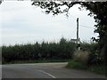
10
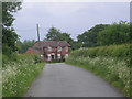
Brook Cottage, Church Eaton Common
Situated beside the lane from Church Eaton to Bradley; it very much looks like an extended 19th century agricultural worker's cottage.
Image: © Richard Law
Taken: 23 Jan 2018
0.20 miles