IMAGES TAKEN NEAR TO
Ivetsey Bank, STAFFORD, ST19 9QU
Introduction
This page details the photographs taken nearby to Ivetsey Bank, ST19 9QU by members of the Geograph project.
The Geograph project started in 2005 with the aim of publishing, organising and preserving representative images for every square kilometre of Great Britain, Ireland and the Isle of Man.

There are currently over 7.5m images from over14,400 individuals and you can help contribute to the project by visiting https://www.geograph.org.uk
Image Map
Images are licensed for reuse under creativecommons.org/licenses/by-sa/2.0
Notes
- Clicking on the map will re-center to the selected point.
- The higher the marker number, the further away the image location is from the centre of the postcode.
Image Listing (8 Images Found)
Images are licensed for reuse under creativecommons.org/licenses/by-sa/2.0
Image
Details
Distance
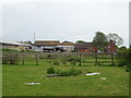
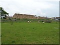
3
Whitegate Farm Campsite
Whitegate Farm Campsite is situated beside the A5 near Wheaton Aston.
Image: © Philip Halling
Taken: 17 May 2018
0.16 miles
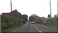
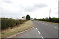
5
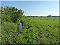
Farmland and a waterway just south of Watling Street
Image: © Richard Law
Taken: 26 May 2012
0.22 miles

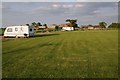
7
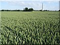
Wheat field at Whitegate Farm
Wheat field beside the campsite at Whitegate Farm beside the A5 near wjeaton Aston.
Image: © Philip Halling
Taken: 7 Jul 2019
0.23 miles