IMAGES TAKEN NEAR TO
Hall Farm Road, STAFFORD, ST19 9EZ
Introduction
This page details the photographs taken nearby to Hall Farm Road, ST19 9EZ by members of the Geograph project.
The Geograph project started in 2005 with the aim of publishing, organising and preserving representative images for every square kilometre of Great Britain, Ireland and the Isle of Man.

There are currently over 7.5m images from over14,400 individuals and you can help contribute to the project by visiting https://www.geograph.org.uk
Image Map
Images are licensed for reuse under creativecommons.org/licenses/by-sa/2.0
Notes
- Clicking on the map will re-center to the selected point.
- The higher the marker number, the further away the image location is from the centre of the postcode.
Image Listing (67 Images Found)
Images are licensed for reuse under creativecommons.org/licenses/by-sa/2.0
Image
Details
Distance
2
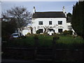
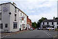
The Lion Hotel, Brewood
Closed, and for sale
Image: © John Lord
Taken: 9 Apr 2010
0.16 miles
5
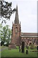
Church of St. Mary the Virgin and St. Chad, Brewood
Church History: http://www.brewoodparish.org.uk/
Image: © Geoff Pick
Taken: 15 May 2004
0.17 miles
6
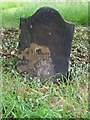
Grave of Col William Careless
The grave of Col William Careless in the churchyard of Brewood church. Careless, the name is also spelt, Carlos and Carless, aided Charles II escape from the Battle of Worcester in September 1651. At Boscobel he hid with the future king up an oak tree.
Image: © Philip Halling
Taken: 7 Jul 2019
0.18 miles
7
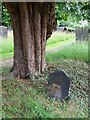
Grave of William Careless
The grave of Col William Careless in the churchyard of Brewood church. Careless, the name is also spelt, Carlos and Carless, aided Charles II escape from the Battle of Worcester in September 1651. At Boscobel he hid with the future king up an oak tree.
Image: © Philip Halling
Taken: 7 Jul 2019
0.18 miles
8
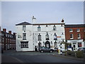
Market Place in Brewood, Staffordshire
The view is to the south-east from Bargate Street, across the northern end of Market Place towards Sandy Lane.
Image: © Roger D Kidd
Taken: 9 Jun 2018
0.19 miles
9
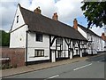
Timber-framed house
Timber-framed house on Dean Street in Brewood. Interesting house originally a Hall House dating from the 14th century. The house is Grade II listed, see: https://historicengland.org.uk/listing/the-list/list-entry/1295164
Image: © Philip Halling
Taken: 7 Jul 2019
0.19 miles
10
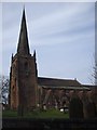
Church of St Mary the Virgin & St Chad, Brewood
Image: © John Lord
Taken: 9 Apr 2010
0.19 miles