IMAGES TAKEN NEAR TO
Royal Oak Drive, STAFFORD, ST19 9AN
Introduction
This page details the photographs taken nearby to Royal Oak Drive, ST19 9AN by members of the Geograph project.
The Geograph project started in 2005 with the aim of publishing, organising and preserving representative images for every square kilometre of Great Britain, Ireland and the Isle of Man.

There are currently over 7.5m images from over14,400 individuals and you can help contribute to the project by visiting https://www.geograph.org.uk
Image Map (Loading...)


Getting Data...Please wait
Leaflet Map data © OpenStreetMap
Images are licensed for reuse under creativecommons.org/licenses/by-sa/2.0
Notes
- Clicking on the map will re-center to the selected point.
- The higher the marker number, the further away the image location is from the centre of the postcode.
Image Listing (39 Images Found)
Images are licensed for reuse under creativecommons.org/licenses/by-sa/2.0
Image
Details
Distance
1
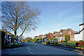
Old Weston Road in Bishopswood, Staffordshire
Looking north-north-west from near the junction with Royal Oak Drive (off to the left).
Image: © Roger Kidd
Taken: 30 Nov 2022
0.05 miles
2
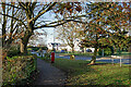
Whiteoakes Drive in Bishopswood, Staffordshire
Looking north. St John's First School is behind the camera, and Royal Oak Drive is off to the right.
Image: © Roger Kidd
Taken: 30 Nov 2022
0.06 miles
3

Old Weston Road in Bishopswood, Staffordshire
Looking north-west into the village from near the junction with Ivetsey Bank Road.
Image: © Roger Kidd
Taken: 30 Nov 2022
0.07 miles
4
Old Weston Road in Bishopswood, Staffordshire
Looking north-west into the village from the junction with Ivetsey Bank Road.
Image: © Roger Kidd
Taken: 30 Nov 2022
0.08 miles
5
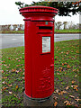
Post box at Bishopswood in Staffordshire
The post box is by Old Weston Road near the junction with Ivetsey Bank Road.
Box number ST19 190
Image]
Image: © Roger Kidd
Taken: 30 Nov 2022
0.10 miles
6
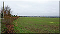
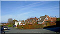
Staffordshire farmland near Bishopswood
Looking north towards Ivetsey Bank. Ivetsey Bank Road is behind the hedge on the left.
Image: © Roger Kidd
Taken: 30 Nov 2022
0.11 miles
7
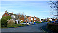
Whiteoaks Drive in Bishopswood, Staffordshire
Looking east towards Old Weston Road. Tong Close is off to the left.
Image: © Roger Kidd
Taken: 30 Nov 2022
0.11 miles
8
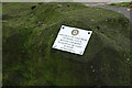
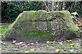
Bishopswood village name stone in Staffordshire
Image]
The stone is at the Ivetsey Bank Road crossroads by the bus shelter, north of the Royal Oak public house.
On the rear are two plaques.
DONATED IN THE YEAR 2005 BY:
THE ROTARY CLUB OF
BREWOOD AND DISTRICT
TO CELEBRATE "100 YEARS"
OF ROTARY
INTERNATIONAL
and
Foundations Provided by:
South Staffordshire
District Council
Image: © Roger Kidd
Taken: 30 Nov 2022
0.12 miles
9
Bishopswood village name stone in Staffordshire
Rear view. The stone is at the Ivetsey Bank Road crossroads by the bus shelter, north of the Royal Oak public house.
Image]
On the rear are two plaques.
DONATED IN THE YEAR 2005 BY:
THE ROTARY CLUB OF
BREWOOD AND DISTRICT
TO CELEBRATE "100 YEARS"
OF ROTARY
INTERNATIONAL
and
Foundations Provided by:
South Staffordshire
District Council
Image: © Roger Kidd
Taken: 30 Nov 2022
0.12 miles
10
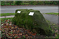
Bishopswood village name stone in Staffordshire
The stone is at the Ivetsey Bank Road crossroads by the bus shelter, north of the Royal Oak public house.
On the rear are two plaques.
DONATED IN THE YEAR 2005 BY:
THE ROTARY CLUB OF
BREWOOD AND DISTRICT
TO CELEBRATE "100 YEARS"
OF ROTARY
INTERNATIONAL
and
Foundations Provided by:
South Staffordshire
District Council
Image]
Image]
Image: © Roger Kidd
Taken: 30 Nov 2022
0.12 miles