IMAGES TAKEN NEAR TO
Marston Gate, STAFFORD, ST18 9SZ
Introduction
This page details the photographs taken nearby to ST18 9SZ by members of the Geograph project.
The Geograph project started in 2005 with the aim of publishing, organising and preserving representative images for every square kilometre of Great Britain, Ireland and the Isle of Man.

There are currently over 7.5m images from over14,400 individuals and you can help contribute to the project by visiting https://www.geograph.org.uk
Image Map (Loading...)


Getting Data...Please wait
Leaflet Map data © OpenStreetMap
Images are licensed for reuse under creativecommons.org/licenses/by-sa/2.0
Notes
- Clicking on the map will re-center to the selected point.
- The higher the marker number, the further away the image location is from the centre of the postcode.
Image Listing (20 Images Found)
Images are licensed for reuse under creativecommons.org/licenses/by-sa/2.0
Image
Details
Distance
1
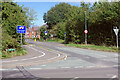
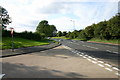
Marston Lane
Marston Lane leads north off the A513 Beaconside towards the scattered settlement of Marston. This is part of the area designated as North Stafford Development Location, which will eventually comprise 3,100 homes, and new houses have already begun to appear.
Image: © Stephen McKay
Taken: 24 Sep 2020
0.03 miles
2
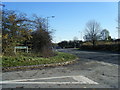
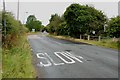
Common Road, Stafford
This is the junction of Common Road with Beaconside on the northern edge of Stafford.
Image: © Stephen Pearce
Taken: 7 Oct 2006
0.04 miles
4
Beaconside, Stafford
This is Beaconside at the junction of Common Road, Stafford. In the background can be seen part of the RAF buildings and behind the hedge to the right can be seen a new industrial unit.
Image: © Stephen Pearce
Taken: 7 Oct 2006
0.05 miles
5
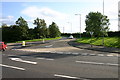
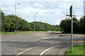
Beaconside junction of Common Road, Stafford
On the right just up ahead is a turning for Marston. Beaconside leads to the A34 in the direction of this photo.
Image: © Stephen Pearce
Taken: 7 Oct 2006
0.05 miles
6
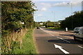
Beaconside
Beaconside is a part of the A513 forming Stafford's eastern by-pass. However, because a section of the by-pass has never been built it is detached from the rest of the A513 road. In this view Common Road leads off to the right across Stafford Common.
Image: © Stephen McKay
Taken: 24 Sep 2020
0.07 miles
7
Common Road to A513 Beaconside Ring Road
Image: © Mick Malpass
Taken: 17 Jul 2011
0.08 miles
8
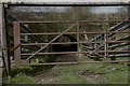
Beaconside Underpass
Livestock underpass connecting the north and south of Stafford Common beneath the A513/Beaconside.
Image: © Richard
Taken: 9 Mar 2019
0.08 miles
9
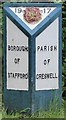
Old Boundary Marker by the A513, Beaconside, Stafford Parish
Parish Boundary Marker by the A513, in parish of Stafford (Stafford District), Parkside, at bridge over Marston Brook.
Surveyed
Milestone Society National ID: ST_SFCR02pb
Image: © M Bardell
Taken: Unknown
0.10 miles
10
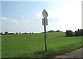
Stafford Common
'No Golf' An interesting sign at the side of the common, presumably to prevent stray balls hitting walkers or being eaten by the cattle and horses that graze the common proper.
To judge by the spotty appearance of the round upper sign similar strictures may soon be needed for airguns!
Image: © Simon Huguet
Taken: 18 Sep 2008
0.11 miles