IMAGES TAKEN NEAR TO
Coton Clanford, STAFFORD, ST18 9PE
Introduction
This page details the photographs taken nearby to ST18 9PE by members of the Geograph project.
The Geograph project started in 2005 with the aim of publishing, organising and preserving representative images for every square kilometre of Great Britain, Ireland and the Isle of Man.

There are currently over 7.5m images from over14,400 individuals and you can help contribute to the project by visiting https://www.geograph.org.uk
Image Map (Loading...)


Getting Data...Please wait
Leaflet Map data © OpenStreetMap
Images are licensed for reuse under creativecommons.org/licenses/by-sa/2.0
Notes
- Clicking on the map will re-center to the selected point.
- The higher the marker number, the further away the image location is from the centre of the postcode.
Image Listing (5 Images Found)
Images are licensed for reuse under creativecommons.org/licenses/by-sa/2.0
Image
Details
Distance
1
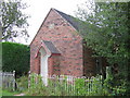
Coton Clanford Church
The very small church at the hamlet of Coton Clanford is now closed
Image: © Andrew Spenceley
Taken: 27 Aug 2006
0.10 miles
4
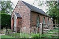
Primitive Methodist Chapel
This chapel has an information plaque above the door giving the date as AD 1884. http://www.geograph.org.uk/photo/2553335 to information plaque.
Image: © Mick Malpass
Taken: 14 Aug 2011
0.20 miles
5
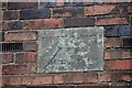
Information Plaque for Chapel
This plaque dates the chapel to 1884. http://www.geograph.org.uk/photo/2552963 to Primitive Methodist chapel.
Image: © Mick Malpass
Taken: 14 Aug 2011
0.20 miles