IMAGES TAKEN NEAR TO
Castle View, STAFFORD, ST18 9NG
Introduction
This page details the photographs taken nearby to Castle View, ST18 9NG by members of the Geograph project.
The Geograph project started in 2005 with the aim of publishing, organising and preserving representative images for every square kilometre of Great Britain, Ireland and the Isle of Man.

There are currently over 7.5m images from over14,400 individuals and you can help contribute to the project by visiting https://www.geograph.org.uk
Image Map (Loading...)


Getting Data...Please wait
Leaflet Map data © OpenStreetMap
Images are licensed for reuse under creativecommons.org/licenses/by-sa/2.0
Notes
- Clicking on the map will re-center to the selected point.
- The higher the marker number, the further away the image location is from the centre of the postcode.
Image Listing (19 Images Found)
Images are licensed for reuse under creativecommons.org/licenses/by-sa/2.0
Image
Details
Distance
5

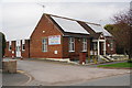
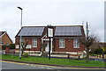
Entrance to Derrington Village Hall
Dated 1931.
Image: © JThomas
Taken: 14 Mar 2020
0.09 miles
6
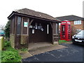
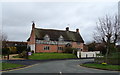
Derrington Village Hall
On Billington Lane.
Showing position of Postbox No. ST18 91.
See Image] for postbox.
Image: © JThomas
Taken: 14 Mar 2020
0.09 miles
7
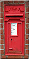
Victorian postbox on Billington Lane, Derrington
Postbox No. ST18 91.
See Image] for context.
Image: © JThomas
Taken: 14 Mar 2020
0.09 miles
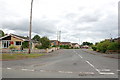
10
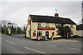
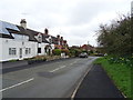
The Red Lion, Derrington
It was too early in the day for it to be open, so I haven't seen the interior or the beer range.
Image: © Bill Boaden
Taken: 2 Apr 2011
0.18 miles