IMAGES TAKEN NEAR TO
Aston, STAFFORD, ST18 9LJ
Introduction
This page details the photographs taken nearby to ST18 9LJ by members of the Geograph project.
The Geograph project started in 2005 with the aim of publishing, organising and preserving representative images for every square kilometre of Great Britain, Ireland and the Isle of Man.

There are currently over 7.5m images from over14,400 individuals and you can help contribute to the project by visiting https://www.geograph.org.uk
Image Map (Loading...)


Getting Data...Please wait
Leaflet Map data © OpenStreetMap
Images are licensed for reuse under creativecommons.org/licenses/by-sa/2.0
Notes
- Clicking on the map will re-center to the selected point.
- The higher the marker number, the further away the image location is from the centre of the postcode.
Image Listing (4 Images Found)
Images are licensed for reuse under creativecommons.org/licenses/by-sa/2.0
Image
Details
Distance
1
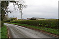
Glen Farm
It was difficult to see behind the hedge. Stafford Castle is on the hill on the right.
Image: © Bill Boaden
Taken: 2 Apr 2011
0.01 miles
2
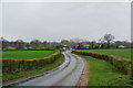
Approaching Little Aston Farm
This is on the lane from Doxey.
Image: © Bill Boaden
Taken: 2 Apr 2011
0.21 miles
3
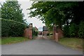
Entrance to Aston Hall
A grade 2 listed building, 17th and 18th century.
Image: © Mick Malpass
Taken: 14 Aug 2011
0.24 miles
4
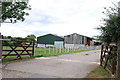
Entrance to Little Aston Farm
This farm is on the junction of Long Lane and Aston Hill.
Image: © Mick Malpass
Taken: 14 Aug 2011
0.24 miles