IMAGES TAKEN NEAR TO
Aston, STAFFORD, ST18 9LG
Introduction
This page details the photographs taken nearby to ST18 9LG by members of the Geograph project.
The Geograph project started in 2005 with the aim of publishing, organising and preserving representative images for every square kilometre of Great Britain, Ireland and the Isle of Man.

There are currently over 7.5m images from over14,400 individuals and you can help contribute to the project by visiting https://www.geograph.org.uk
Image Map (22 Images)


Getting Data...Please wait
Leaflet Map data © OpenStreetMap
Images are licensed for reuse under creativecommons.org/licenses/by-sa/2.0
Notes
- Clicking on the map will re-center to the selected point.
- The higher the marker number, the further away the image location is from the centre of the postcode.
Image Listing (22 Images Found)
Images are licensed for reuse under creativecommons.org/licenses/by-sa/2.0
Image
Details
Distance
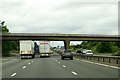
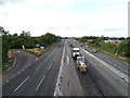
1

M6 North, works vehicle access
The bridge carries Aston Bank, west of Stafford. The view from the bridge is Image
Image: © Robin Stott
Taken: 25 Sep 2010
0.03 miles
4
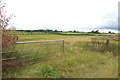
Looking across Pasture Fields, Seighford Road
Image: © Mick Malpass
Taken: 14 Aug 2011
0.06 miles
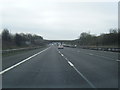
5
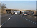
M6 Motorway - minor road overbridge near Doxey
The left-most lane is a slip road to a works unit which can also be used as an emergency access/egress point. A similar arrangement exists on the southbound carriageway.
Image: © Peter Whatley
Taken: 21 Jan 2011
0.06 miles
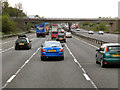
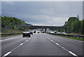
6
Roadworks on the M6 Motorway near Doxey
View from the bridge on Aston Bank.
Image: © JThomas
Taken: 7 Sep 2019
0.06 miles
9
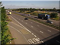
M6, Aston Bank
The view seen in Image from a slightly different angle. I think the depot on this side of the motorway is reciprocated by a similar facility on the other side; the detailed map merely has the cryptic message "Dynamic WB". What looks like a white building above the blue lorry must be the motorway viaduct over the main line railway.
Image: © Derek Harper
Taken: 7 Sep 2012
0.07 miles
10
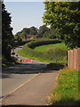
Aston Bank
The road from Doxey just west of its bridge over the M6, with the right turn to Seighford, which you need to take if hoping to get anywhere as the road ahead is closed "access to frontages only". The buildings are at Aston Farm.
Image: © Derek Harper
Taken: 7 Sep 2012
0.08 miles