IMAGES TAKEN NEAR TO
Butt Lane, STAFFORD, ST18 9JZ
Introduction
This page details the photographs taken nearby to Butt Lane, ST18 9JZ by members of the Geograph project.
The Geograph project started in 2005 with the aim of publishing, organising and preserving representative images for every square kilometre of Great Britain, Ireland and the Isle of Man.

There are currently over 7.5m images from over14,400 individuals and you can help contribute to the project by visiting https://www.geograph.org.uk
Image Map (Loading...)


Getting Data...Please wait
Leaflet Map data © OpenStreetMap
Images are licensed for reuse under creativecommons.org/licenses/by-sa/2.0
Notes
- Clicking on the map will re-center to the selected point.
- The higher the marker number, the further away the image location is from the centre of the postcode.
Image Listing (8 Images Found)
Images are licensed for reuse under creativecommons.org/licenses/by-sa/2.0
Image
Details
Distance
1
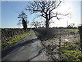
On the lane
A pleasant spring-like lane to trudge.
Image: © Jeremy Bolwell
Taken: 20 Jan 2022
0.07 miles
2
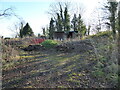
Scruffy little compound with shed
Hard to interpret what is going on here.
Image: © Jeremy Bolwell
Taken: 20 Jan 2022
0.15 miles
3
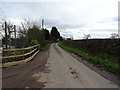
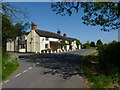
Butt Lane, Ranton Green
Towards Long Compton.
Image: © JThomas
Taken: 14 Mar 2020
0.18 miles
4
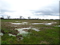
Waterlogged field, Ranton Green
Off Butt Lane.
Image: © JThomas
Taken: 14 Mar 2020
0.20 miles
5
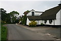
The Hand and Cleaver pub
A well known local pub & restaurant.
Image: © Richard Law
Taken: 25 May 2012
0.21 miles
6
The Hand and Cleaver Restaurant
The Hand and Cleaver at Ranton.
Image: © Stephen Pearce
Taken: 16 Oct 2006
0.21 miles
7
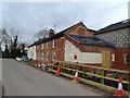
Houses on Butt Lane, Ranton Green
A development of the former Hand and Cleaver public house. See Image]
Image: © JThomas
Taken: 14 Mar 2020
0.22 miles
8
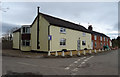
Houses on Butt Lane, Ranton Green
A development of the former Hand and Cleaver public house. See Image]
Image: © JThomas
Taken: 14 Mar 2020
0.23 miles