IMAGES TAKEN NEAR TO
Beech Lane, STAFFORD, ST18 9BT
Introduction
This page details the photographs taken nearby to Beech Lane, ST18 9BT by members of the Geograph project.
The Geograph project started in 2005 with the aim of publishing, organising and preserving representative images for every square kilometre of Great Britain, Ireland and the Isle of Man.

There are currently over 7.5m images from over14,400 individuals and you can help contribute to the project by visiting https://www.geograph.org.uk
Image Map (Loading...)


Getting Data...Please wait
Leaflet Map data © OpenStreetMap
Images are licensed for reuse under creativecommons.org/licenses/by-sa/2.0
Notes
- Clicking on the map will re-center to the selected point.
- The higher the marker number, the further away the image location is from the centre of the postcode.
Image Listing (20 Images Found)
Images are licensed for reuse under creativecommons.org/licenses/by-sa/2.0
Image
Details
Distance
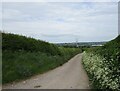
1
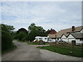
Beech Lane, Coppenhall
A private road.
Image: © Jonathan Thacker
Taken: 3 Jun 2021
0.04 miles
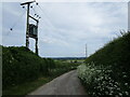
5
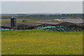
The Lane, Coppenhall
Cannock Chase in the distance.
Image: © Jonathan Thacker
Taken: 3 Jun 2021
0.12 miles
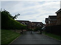
9
Upper Wheats Farm
Cattle sheds and silage clamp.
Image: © John M
Taken: 8 May 2016
0.16 miles
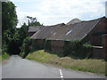
10
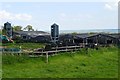
Cow sheds at Upper Wheats Farm
The cows are out to pasture and the sheds are empty. The silage clamps have their obligatory collection of tyres.
Image: © John M
Taken: 8 May 2016
0.16 miles