IMAGES TAKEN NEAR TO
Holden Park, STAFFORD, ST18 0ZQ
Introduction
This page details the photographs taken nearby to Holden Park, ST18 0ZQ by members of the Geograph project.
The Geograph project started in 2005 with the aim of publishing, organising and preserving representative images for every square kilometre of Great Britain, Ireland and the Isle of Man.

There are currently over 7.5m images from over14,400 individuals and you can help contribute to the project by visiting https://www.geograph.org.uk
Image Map
Images are licensed for reuse under creativecommons.org/licenses/by-sa/2.0
Notes
- Clicking on the map will re-center to the selected point.
- The higher the marker number, the further away the image location is from the centre of the postcode.
Image Listing (7 Images Found)
Images are licensed for reuse under creativecommons.org/licenses/by-sa/2.0
Image
Details
Distance
1
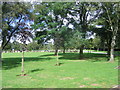
Stafford Crematorium
Stafford Crematorium
Image: © Andrew Spenceley
Taken: 27 Aug 2006
0.10 miles
3
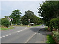
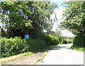
Junction of Baswich Lane and Tixall Road looking towards crematorium
Image: © Tim Marshall
Taken: 15 Aug 2010
0.13 miles
4
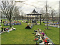
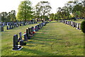
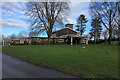
Garden of Remembrance, Stafford Crematorium and Burial Ground
Image: © David Dixon
Taken: 4 Feb 2019
0.16 miles
7
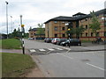
Staffordshire University halls of residence
Image: © Alex McGregor
Taken: 12 May 2011
0.20 miles