IMAGES TAKEN NEAR TO
Common Lane, STAFFORD, ST18 0YU
Introduction
This page details the photographs taken nearby to Common Lane, ST18 0YU by members of the Geograph project.
The Geograph project started in 2005 with the aim of publishing, organising and preserving representative images for every square kilometre of Great Britain, Ireland and the Isle of Man.

There are currently over 7.5m images from over14,400 individuals and you can help contribute to the project by visiting https://www.geograph.org.uk
Image Map (Loading...)


Getting Data...Please wait
Leaflet Map data © OpenStreetMap
Images are licensed for reuse under creativecommons.org/licenses/by-sa/2.0
Notes
- Clicking on the map will re-center to the selected point.
- The higher the marker number, the further away the image location is from the centre of the postcode.
Image Listing (7 Images Found)
Images are licensed for reuse under creativecommons.org/licenses/by-sa/2.0
Image
Details
Distance
1
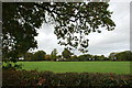
A View over the Hedgerow, Fradswell Lane
Image: © Mick Malpass
Taken: 30 Oct 2011
0.12 miles
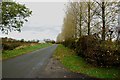
4
Minor Road leaving the Uttoxeter Road towards Fradswell Heath
Image: © Mick Malpass
Taken: 30 Oct 2011
0.20 miles
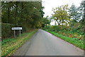
5
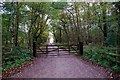
Track and Bridleway to Round House
The horses will have to jump the gate, unless the rider has a key.
Image: © Mick Malpass
Taken: 30 Oct 2011
0.21 miles
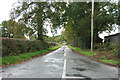
7
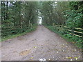
Path to Shaw Wood
This footpath passes through what remains of Shaw Wood.
Image: © Michael Patterson
Taken: 18 Oct 2006
0.23 miles