IMAGES TAKEN NEAR TO
Main Road, STAFFORD, ST18 0TF
Introduction
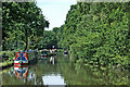
This page details the photographs taken nearby to Main Road, ST18 0TF by members of the Geograph project.
The Geograph project started in 2005 with the aim of publishing, organising and preserving representative images for every square kilometre of Great Britain, Ireland and the Isle of Man.

There are currently over 7.5m images from over14,400 individuals and you can help contribute to the project by visiting https://www.geograph.org.uk
Image Map (Loading...)


Getting Data...Please wait
Leaflet Map data © OpenStreetMap
Images are licensed for reuse under creativecommons.org/licenses/by-sa/2.0
Notes
- Clicking on the map will re-center to the selected point.
- The higher the marker number, the further away the image location is from the centre of the postcode.
Image Listing (82 Images Found)
Images are licensed for reuse under creativecommons.org/licenses/by-sa/2.0
Image
Details
Distance
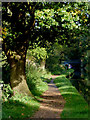
2
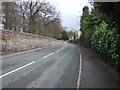
Main road heading north
Towards Great Haywood.
Image: © JThomas
Taken: 19 Apr 2013
0.15 miles
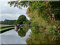
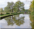
3
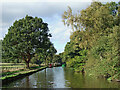
Trent and Mersey Canal near Great Haywood, Staffordshire
Off to the left is the River Trent and the pastures of the Shugborough Estate.
Image: © Roger Kidd
Taken: 16 Oct 2011
0.16 miles
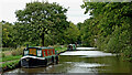
4
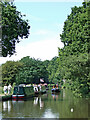
Popular moorings near Great Haywood in Staffordshire
This is the Trent and Mersey Canal, looking north towards Great Haywood Junction and Stone. Off to the left are the River Trent and the pastures of the Shugborough estate, so this is a very popular scenic place to moor.
Image: © Roger Kidd
Taken: 20 Jun 2010
0.16 miles
5
Trent and Mersey Canal near Great Haywood in Staffordshire
This is the Trent and Mersey Canal, looking north towards Great Haywood Junction and Stone. Off to the left are the River Trent and the pastures of the Shugborough estate, so this is a very popular scenic place to moor.
Image: © Roger Kidd
Taken: 20 Jun 2010
0.16 miles
6
Canal towpath south of Great Haywood Junction, Staffordshire
Off to the left is the River Trent. This image shows the Trent and Mersey Canal, looking north towards Great Haywood Junction (about 600 metres distant).
Image: © Roger D Kidd
Taken: 6 Oct 2017
0.16 miles
7
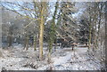
Woodland by the West Coast Main Line on the edge of Great Haywood
Image: © N Chadwick
Taken: 19 Dec 2010
0.16 miles
8
Staffordshire and Worcestershire Canal near Shugborough, Staffordshire
The Shugborough Museum and Estate are on the left, as is the River Trent, with its flood plain, used extensively to graze cattle.
Image: © Roger D Kidd
Taken: 22 Oct 2009
0.17 miles
9
Trent and Mersey Canal near Great Haywood in Staffordshire
Looking north towards Great Haywood Junction and Stoke-on-Trent. The River Trent is close by off to the left, flowing through the Shugborough estate.
Image: © Roger Kidd
Taken: 21 Oct 2011
0.17 miles
10
Trent and Mersey Canal approaching Great Haywood, Staffordshire
Shugborough Park to the left of this image includes the flood plain of the River Trent. During normal river conditions, cattle and sheep are grazed here.
Image: © Roger D Kidd
Taken: 22 Oct 2009
0.17 miles